|
|
|||||||||||||||||
| Point ID: 6316 | Downloads | Plots | Site Data | Code: 3556 |
|
|
|||||||||||||||||
| Download | |
|---|---|
| Site Descriptor Information | Site Time Series Data |
| Link to all available data | |
|
|
| View: | Statistics | Time Series |
| Units: | mm |
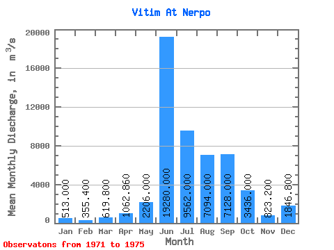
| Statistic | Jan | Feb | Mar | Apr | May | Jun | Jul | Aug | Sep | Oct | Nov | Dec | Annual |
|---|---|---|---|---|---|---|---|---|---|---|---|---|---|
| Mean | 513.00 | 355.40 | 619.80 | 1062.86 | 2206.00 | 19280.00 | 9562.00 | 7094.00 | 7128.00 | 3436.00 | 823.20 | 1846.80 | 4493.92 |
| Standard Deviation | 176.45 | 143.18 | 898.75 | 2022.55 | 2191.31 | 4879.75 | 2480.72 | 2947.76 | 1148.44 | 792.26 | 226.82 | 2774.30 | 1031.18 |
| Min | 367.00 | 243.00 | 123.00 | 90.30 | 344.00 | 13600.00 | 7150.00 | 2760.00 | 5560.00 | 2440.00 | 611.00 | 435.00 | 3723.94 |
| Max | 807.00 | 592.00 | 2220.00 | 4680.00 | 5130.00 | 27000.00 | 13700.00 | 9890.00 | 8200.00 | 4410.00 | 1200.00 | 6800.00 | 6271.08 |
| Coefficient of Variation | 0.34 | 0.40 | 1.45 | 1.90 | 0.99 | 0.25 | 0.26 | 0.42 | 0.16 | 0.23 | 0.28 | 1.50 | 0.23 |
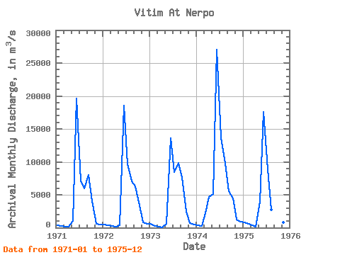
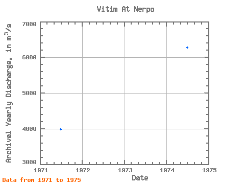
| Year | Jan | Feb | Mar | Apr | May | Jun | Jul | Aug | Sep | Oct | Nov | Dec | Annual | 1971 | 367.00 | 247.00 | 160.00 | 152.00 | 1000.00 | 19600.00 | 7150.00 | 6020.00 | 8020.00 | 4010.00 | 611.00 | 513.00 | 3987.50 | 1972 | 451.00 | 375.00 | 248.00 | 177.00 | 344.00 | 18600.00 | 9630.00 | 7060.00 | 6300.00 | 3370.00 | 829.00 | 595.00 | 3998.25 | 1973 | 538.00 | 243.00 | 123.00 | 90.30 | 586.00 | 13600.00 | 8490.00 | 9890.00 | 7560.00 | 2440.00 | 692.00 | 435.00 | 3723.94 | 1974 | 402.00 | 320.00 | 2220.00 | 4680.00 | 5130.00 | 27000.00 | 13700.00 | 9740.00 | 5560.00 | 4410.00 | 1200.00 | 891.00 | 6271.08 | 1975 | 807.00 | 592.00 | 348.00 | 215.00 | 3970.00 | 17600.00 | 8840.00 | 2760.00 | 8200.00 | 2950.00 | 784.00 | 6800.00 | 4488.83 |
|---|
 Return to R-Arctic Net Home Page