|
|
|||||||||||||||||
| Point ID: 6313 | Downloads | Plots | Site Data | Other Close Sites | Code: 3552 |
|
|
|||||||||||||||||
| Download | |
|---|---|
| Site Descriptor Information | Site Time Series Data |
| Link to all available data | |
| View: | Time Series | All |
| Units: | m3/s |
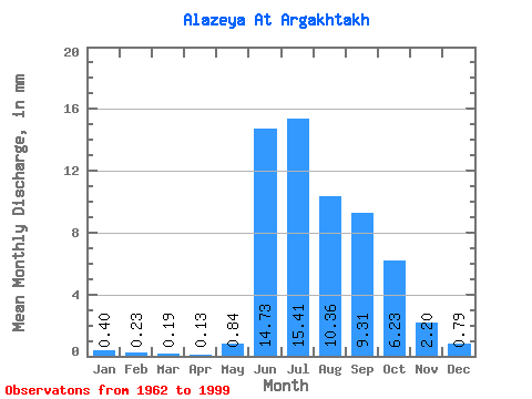
| Statistic | Jan | Feb | Mar | Apr | May | Jun | Jul | Aug | Sep | Oct | Nov | Dec | Annual |
|---|---|---|---|---|---|---|---|---|---|---|---|---|---|
| Mean | 0.41 | 0.23 | 0.19 | 0.13 | 0.84 | 14.73 | 15.41 | 10.36 | 9.31 | 6.23 | 2.20 | 0.79 | 64.06 |
| Standard Deviation | 0.38 | 0.26 | 0.22 | 0.15 | 0.89 | 5.44 | 7.77 | 7.08 | 7.63 | 6.92 | 2.50 | 0.77 | 28.34 |
| Min | 0.01 | 0.00 | 0.00 | 0.00 | 0.01 | 3.63 | 1.57 | 1.39 | 0.99 | 0.52 | 0.14 | 0.01 | 16.80 |
| Max | 1.63 | 1.11 | 0.83 | 0.60 | 3.77 | 22.84 | 29.35 | 26.63 | 26.95 | 25.87 | 10.22 | 3.48 | 122.33 |
| Coefficient of Variation | 0.95 | 1.16 | 1.16 | 1.15 | 1.07 | 0.37 | 0.50 | 0.68 | 0.82 | 1.11 | 1.14 | 0.97 | 0.44 |
| Other Close Sites | ||||||
|---|---|---|---|---|---|---|
| PointID | Latitude | Longitude | Drainage Area | Source | Name | |
| 6354 | "Alazeya At Argakhtakh" | 68.50 | 2125574 | SHI | 825.00 | |
 Return to R-Arctic Net Home Page