|
|
|||||||||||||||||
| Point ID: 631 | Downloads | Plots | Site Data | Code: 07AG002 |
|
|
|||||||||||||||||
| Download | |
|---|---|
| Site Descriptor Information | Site Time Series Data |
| Link to all available data | |
|
|
| View: | Statistics | Time Series |
| Units: | mm |
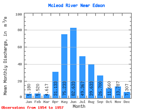
| Statistic | Jan | Feb | Mar | Apr | May | Jun | Jul | Aug | Sep | Oct | Nov | Dec | Annual |
|---|---|---|---|---|---|---|---|---|---|---|---|---|---|
| Mean | 5.18 | 5.52 | 4.62 | 31.13 | 75.23 | 82.63 | 49.37 | 39.63 | 26.70 | 11.66 | 13.79 | 7.31 | 27.09 |
| Standard Deviation | 0.53 | 1.04 | 0.44 | 5.91 | 21.93 | 34.73 | 19.94 | 22.98 | 17.45 | 2.60 | 8.37 | 1.06 | 7.33 |
| Min | 4.57 | 4.33 | 4.25 | 25.00 | 50.50 | 56.30 | 28.40 | 24.70 | 12.30 | 9.82 | 6.66 | 6.32 | 21.90 |
| Max | 5.54 | 6.27 | 5.10 | 36.80 | 92.30 | 122.00 | 68.10 | 66.10 | 46.10 | 13.50 | 23.00 | 8.43 | 32.27 |
| Coefficient of Variation | 0.10 | 0.19 | 0.10 | 0.19 | 0.29 | 0.42 | 0.40 | 0.58 | 0.65 | 0.22 | 0.61 | 0.14 | 0.27 |
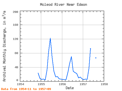
| Year | Jan | Feb | Mar | Apr | May | Jun | Jul | Aug | Sep | Oct | Nov | Dec | Annual | 1954 | 23.00 | 8.43 | 1955 | 5.54 | 5.96 | 4.25 | 31.60 | 82.90 | 122.00 | 68.10 | 28.10 | 12.30 | 13.50 | 6.66 | 6.32 | 32.27 | 1956 | 5.43 | 4.33 | 4.50 | 25.00 | 50.50 | 69.60 | 28.40 | 24.70 | 21.70 | 9.82 | 11.70 | 7.17 | 21.90 | 1957 | 4.57 | 6.27 | 5.10 | 36.80 | 92.30 | 56.30 | 51.60 | 66.10 | 46.10 |
|---|
 Return to R-Arctic Net Home Page