|
|
|||||||||||||||||
| Point ID: 6237 | Downloads | Plots | Site Data | Code: 3231 |
|
|
|||||||||||||||||
| Download | |
|---|---|
| Site Descriptor Information | Site Time Series Data |
| Link to all available data | |
| View: | Time Series | All |
| Units: | mm |
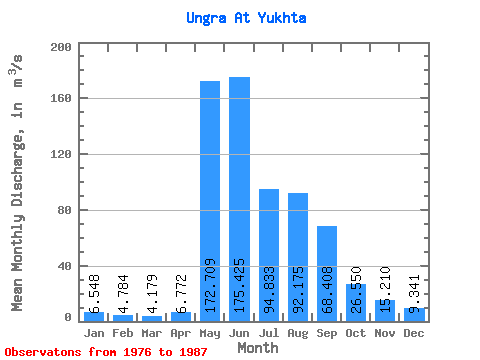
| Statistic | Jan | Feb | Mar | Apr | May | Jun | Jul | Aug | Sep | Oct | Nov | Dec | Annual |
|---|---|---|---|---|---|---|---|---|---|---|---|---|---|
| Mean | 6.55 | 4.78 | 4.18 | 6.77 | 172.71 | 175.43 | 94.83 | 92.17 | 68.41 | 26.55 | 15.21 | 9.34 | 56.03 |
| Standard Deviation | 3.00 | 2.28 | 2.16 | 3.82 | 66.48 | 68.04 | 41.67 | 48.08 | 34.20 | 11.37 | 7.77 | 4.01 | 14.76 |
| Min | 3.09 | 1.77 | 1.44 | 2.69 | 73.20 | 85.20 | 41.30 | 36.30 | 29.50 | 12.70 | 6.35 | 4.29 | 30.68 |
| Max | 11.30 | 8.03 | 8.74 | 15.30 | 296.00 | 288.00 | 153.00 | 197.00 | 134.00 | 56.70 | 35.40 | 15.60 | 72.64 |
| Coefficient of Variation | 0.46 | 0.48 | 0.52 | 0.56 | 0.39 | 0.39 | 0.44 | 0.52 | 0.50 | 0.43 | 0.51 | 0.43 | 0.26 |
 Return to R-Arctic Net Home Page