|
|
|||||||||||||||||
| Point ID: 6237 | Downloads | Plots | Site Data | Code: 3231 |
|
|
|||||||||||||||||
| Download | |
|---|---|
| Site Descriptor Information | Site Time Series Data |
| Link to all available data | |
| View: | Time Series | All |
| Units: | m3/s |
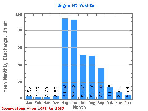
| Statistic | Jan | Feb | Mar | Apr | May | Jun | Jul | Aug | Sep | Oct | Nov | Dec | Annual |
|---|---|---|---|---|---|---|---|---|---|---|---|---|---|
| Mean | 3.56 | 2.37 | 2.27 | 3.57 | 94.01 | 92.42 | 51.62 | 50.17 | 36.04 | 14.45 | 8.01 | 5.08 | 359.43 |
| Standard Deviation | 1.63 | 1.13 | 1.18 | 2.02 | 36.19 | 35.84 | 22.68 | 26.17 | 18.02 | 6.19 | 4.09 | 2.18 | 94.65 |
| Min | 1.68 | 0.88 | 0.78 | 1.42 | 39.84 | 44.89 | 22.48 | 19.76 | 15.54 | 6.91 | 3.34 | 2.33 | 196.79 |
| Max | 6.15 | 3.98 | 4.76 | 8.06 | 161.12 | 151.73 | 83.28 | 107.23 | 70.59 | 30.86 | 18.65 | 8.49 | 465.98 |
| Coefficient of Variation | 0.46 | 0.48 | 0.52 | 0.56 | 0.39 | 0.39 | 0.44 | 0.52 | 0.50 | 0.43 | 0.51 | 0.43 | 0.26 |
 Return to R-Arctic Net Home Page