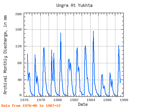
| Point ID: 6237 | Downloads | Plots | Site Data | Code: 3231 |
| Download | |
|---|---|
| Site Descriptor Information | Site Time Series Data |
| Link to all available data | |

|

|
| View: | Statistics | Time Series |
| Units: | m3/s |
| Statistic | Jan | Feb | Mar | Apr | May | Jun | Jul | Aug | Sep | Oct | Nov | Dec | Annual |
|---|---|---|---|---|---|---|---|---|---|---|---|---|---|
| Mean | 3.56 | 2.37 | 2.27 | 3.57 | 94.01 | 92.42 | 51.62 | 50.17 | 36.04 | 14.45 | 8.01 | 5.08 | 359.43 |
| Standard Deviation | 1.63 | 1.13 | 1.18 | 2.02 | 36.19 | 35.84 | 22.68 | 26.17 | 18.02 | 6.19 | 4.09 | 2.18 | 94.65 |
| Min | 1.68 | 0.88 | 0.78 | 1.42 | 39.84 | 44.89 | 22.48 | 19.76 | 15.54 | 6.91 | 3.34 | 2.33 | 196.79 |
| Max | 6.15 | 3.98 | 4.76 | 8.06 | 161.12 | 151.73 | 83.28 | 107.23 | 70.59 | 30.86 | 18.65 | 8.49 | 465.98 |
| Coefficient of Variation | 0.46 | 0.48 | 0.52 | 0.56 | 0.39 | 0.39 | 0.44 | 0.52 | 0.50 | 0.43 | 0.51 | 0.43 | 0.26 |
| Year | Jan | Feb | Mar | Apr | May | Jun | Jul | Aug | Sep | Oct | Nov | Dec | Annual | 1976 | 101.68 | 38.10 | 58.24 | 56.37 | 15.13 | 9.01 | 5.44 | 1977 | 4.46 | 3.14 | 2.52 | 2.57 | 102.33 | 50.10 | 31.73 | 50.51 | 36.03 | 12.90 | 5.74 | 3.86 | 303.80 | 1978 | 2.09 | 1.05 | 1.83 | 3.08 | 117.03 | 116.43 | 82.73 | 36.74 | 27.45 | 14.97 | 7.80 | 7.18 | 416.03 | 1979 | 6.15 | 1.90 | 1.67 | 2.12 | 114.31 | 44.89 | 37.83 | 107.23 | 51.84 | 16.06 | 9.80 | 6.86 | 397.19 | 1980 | 4.79 | 3.54 | 3.17 | 1.99 | 71.30 | 151.73 | 68.58 | 33.48 | 16.23 | 6.91 | 4.24 | 2.33 | 367.71 | 1981 | 3.58 | 3.02 | 1.91 | 3.02 | 90.36 | 89.03 | 63.14 | 83.28 | 70.59 | 30.86 | 18.65 | 6.70 | 462.01 | 1982 | 2.58 | 3.34 | 3.15 | 8.06 | 111.58 | 116.43 | 61.51 | 72.39 | 47.36 | 12.14 | 10.85 | 8.49 | 455.96 | 1983 | 5.99 | 3.98 | 4.76 | 4.76 | 118.11 | 121.70 | 83.28 | 43.98 | 44.78 | 20.19 | 9.06 | 7.51 | 465.98 | 1984 | 3.90 | 2.74 | 2.97 | 5.64 | 161.12 | 94.30 | 35.16 | 20.36 | 15.54 | 9.25 | 6.58 | 2.83 | 358.16 | 1985 | 1.68 | 0.88 | 0.78 | 4.67 | 49.86 | 52.68 | 22.48 | 19.76 | 25.34 | 11.65 | 4.44 | 3.18 | 196.79 | 1986 | 1.84 | 1.11 | 0.95 | 1.42 | 58.24 | 47.84 | 22.48 | 40.99 | 17.07 | 12.14 | 3.34 | 2.75 | 208.76 | 1987 | 2.14 | 1.39 | 1.32 | 1.92 | 39.84 | 122.22 | 72.39 | 35.11 | 23.86 | 11.21 | 6.64 | 3.88 | 321.33 |
|---|
 Return to R-Arctic Net Home Page