|
|
|||||||||||||||||
| Point ID: 6195 | Downloads | Plots | Site Data | Code: 3134 |
|
|
|||||||||||||||||
| Download | |
|---|---|
| Site Descriptor Information | Site Time Series Data |
| Link to all available data | |
| View: | Time Series | All |
| Units: | m3/s |
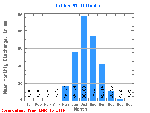
| Statistic | Jan | Feb | Mar | Apr | May | Jun | Jul | Aug | Sep | Oct | Nov | Dec | Annual |
|---|---|---|---|---|---|---|---|---|---|---|---|---|---|
| Mean | 0.00 | 0.00 | 0.00 | 0.27 | 16.71 | 55.79 | 96.62 | 74.26 | 42.14 | 10.95 | 2.65 | 0.25 | 297.18 |
| Standard Deviation | 0.00 | 0.00 | 0.00 | 0.50 | 16.90 | 37.11 | 74.11 | 46.50 | 22.23 | 3.67 | 1.18 | 0.26 | 115.32 |
| Min | 0.00 | 0.00 | 0.00 | 0.00 | 2.72 | 6.40 | 14.26 | 16.19 | 18.49 | 5.39 | 0.99 | 0.00 | 87.41 |
| Max | 0.00 | 0.00 | 0.00 | 1.68 | 87.82 | 153.61 | 319.79 | 200.06 | 113.59 | 20.20 | 7.05 | 1.22 | 569.38 |
| Coefficient of Variation | 1.86 | 1.01 | 0.67 | 0.77 | 0.63 | 0.53 | 0.34 | 0.45 | 1.05 | 0.39 |
 Return to R-Arctic Net Home Page