|
|
|||||||||||||||||
| Point ID: 6175 | Downloads | Plots | Site Data | Code: 3103 |
|
|
|||||||||||||||||
| Download | |
|---|---|
| Site Descriptor Information | Site Time Series Data |
| Link to all available data | |
|
|
| View: | Statistics | Time Series |
| Units: | mm |
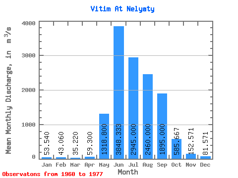
| Statistic | Jan | Feb | Mar | Apr | May | Jun | Jul | Aug | Sep | Oct | Nov | Dec | Annual |
|---|---|---|---|---|---|---|---|---|---|---|---|---|---|
| Mean | 53.54 | 43.06 | 35.22 | 59.30 | 1318.80 | 3848.33 | 2945.00 | 2460.00 | 1895.00 | 585.67 | 152.57 | 81.57 | 1124.84 |
| Standard Deviation | 15.60 | 15.65 | 11.46 | 25.05 | 726.14 | 1189.78 | 1688.93 | 1079.70 | 767.82 | 166.58 | 42.22 | 19.76 | 237.37 |
| Min | 30.60 | 20.20 | 16.70 | 33.00 | 828.00 | 2330.00 | 1730.00 | 1430.00 | 1060.00 | 358.00 | 92.00 | 55.50 | 942.84 |
| Max | 69.10 | 61.40 | 46.50 | 97.60 | 2580.00 | 5330.00 | 6240.00 | 4080.00 | 3300.00 | 777.00 | 221.00 | 111.00 | 1526.41 |
| Coefficient of Variation | 0.29 | 0.36 | 0.33 | 0.42 | 0.55 | 0.31 | 0.57 | 0.44 | 0.41 | 0.28 | 0.28 | 0.24 | 0.21 |
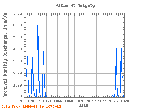
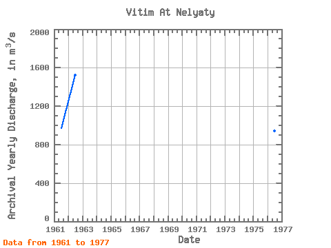
| Year | Jan | Feb | Mar | Apr | May | Jun | Jul | Aug | Sep | Oct | Nov | Dec | Annual | 1960 | 2330.00 | 1730.00 | 3420.00 | 3300.00 | 777.00 | 221.00 | 111.00 | 1961 | 67.10 | 61.40 | 46.50 | 69.50 | 846.00 | 3740.00 | 2130.00 | 1730.00 | 1910.00 | 726.00 | 182.00 | 105.00 | 967.79 | 1962 | 69.10 | 52.60 | 36.30 | 97.60 | 2580.00 | 5330.00 | 6240.00 | 1430.00 | 1640.00 | 612.00 | 160.00 | 69.30 | 1526.41 | 1963 | 49.60 | 43.50 | 42.50 | 48.80 | 1100.00 | 4410.00 | 3210.00 | 2470.00 | 1450.00 | 624.00 | 159.00 | 77.20 | 1140.38 | 1975 | 133.00 | 80.20 | 1976 | 51.30 | 37.60 | 34.10 | 47.60 | 828.00 | 2600.00 | 2070.00 | 4080.00 | 1060.00 | 358.00 | 92.00 | 55.50 | 942.84 | 1977 | 30.60 | 20.20 | 16.70 | 33.00 | 1240.00 | 4680.00 | 2290.00 | 1630.00 | 2010.00 | 417.00 | 121.00 | 72.80 | 1046.78 |
|---|
 Return to R-Arctic Net Home Page