|
|
|||||||||||||||||
| Point ID: 6174 | Downloads | Plots | Site Data | Other Close Sites | Code: 3102 |
|
|
|||||||||||||||||
| Download | |
|---|---|
| Site Descriptor Information | Site Time Series Data |
| Link to all available data | |
| View: | Time Series | All |
| Units: | m3/s |
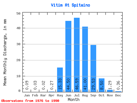
| Statistic | Jan | Feb | Mar | Apr | May | Jun | Jul | Aug | Sep | Oct | Nov | Dec | Annual |
|---|---|---|---|---|---|---|---|---|---|---|---|---|---|
| Mean | 0.09 | 0.03 | 0.02 | 0.27 | 15.32 | 44.49 | 46.59 | 40.99 | 29.53 | 8.50 | 1.29 | 0.35 | 186.59 |
| Standard Deviation | 0.05 | 0.02 | 0.01 | 0.33 | 12.54 | 24.74 | 28.91 | 22.55 | 16.40 | 4.41 | 0.62 | 0.18 | 68.59 |
| Min | 0.03 | 0.01 | 0.00 | 0.03 | 2.59 | 14.97 | 9.42 | 10.45 | 10.78 | 3.35 | 0.53 | 0.13 | 87.07 |
| Max | 0.17 | 0.07 | 0.05 | 1.10 | 54.27 | 111.06 | 119.89 | 88.50 | 74.33 | 17.91 | 2.80 | 0.78 | 350.93 |
| Coefficient of Variation | 0.52 | 0.64 | 0.55 | 1.24 | 0.82 | 0.56 | 0.62 | 0.55 | 0.56 | 0.52 | 0.49 | 0.51 | 0.37 |
| Other Close Sites | ||||||
|---|---|---|---|---|---|---|
| PointID | Latitude | Longitude | Drainage Area | Source | Name | |
| 6173 | "Vitim At Mnogoob. Kosa" | 56.08 | 1616013 | SHI | 771.00 | |
 Return to R-Arctic Net Home Page