|
|
|||||||||||||||||
| Point ID: 6174 | Downloads | Plots | Site Data | Other Close Sites | Code: 3102 |
|
|
|||||||||||||||||
| Download | |
|---|---|
| Site Descriptor Information | Site Time Series Data |
| Link to all available data | |
|
|
| View: | Statistics | Time Series |
| Units: | mm |
| Statistic | Jan | Feb | Mar | Apr | May | Jun | Jul | Aug | Sep | Oct | Nov | Dec | Annual |
|---|---|---|---|---|---|---|---|---|---|---|---|---|---|
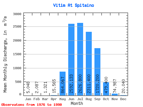
| Mean | 5.05 | 2.09 | 1.32 | 15.56 | 864.07 | 2592.13 | 2626.80 | 2311.40 | 1720.20 | 479.40 | 74.99 | 20.04 | 892.75 |
| Standard Deviation | 2.62 | 1.34 | 0.72 | 19.36 | 706.82 | 1441.24 | 1629.93 | 1271.70 | 955.56 | 248.80 | 36.41 | 10.22 | 328.16 |
| Min | 1.85 | 0.36 | 0.23 | 1.94 | 146.00 | 872.00 | 531.00 | 589.00 | 628.00 | 189.00 | 30.70 | 7.10 | 416.59 |
| Max | 9.64 | 4.63 | 2.66 | 64.40 | 3060.00 | 6470.00 | 6760.00 | 4990.00 | 4330.00 | 1010.00 | 163.00 | 44.00 | 1679.02 |
| Coefficient of Variation | 0.52 | 0.64 | 0.55 | 1.24 | 0.82 | 0.56 | 0.62 | 0.55 | 0.56 | 0.52 | 0.49 | 0.51 | 0.37 |
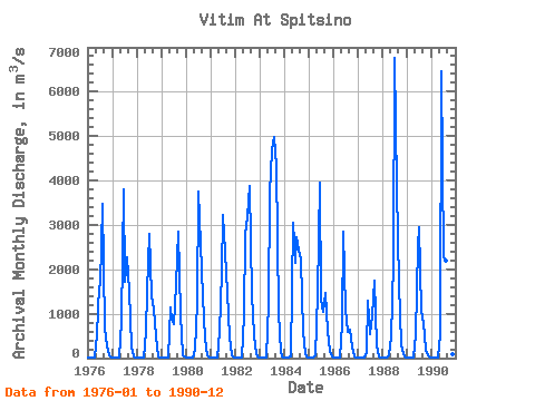
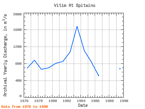
| Year | Jan | Feb | Mar | Apr | May | Jun | Jul | Aug | Sep | Oct | Nov | Dec | Annual | 1976 | 5.39 | 2.03 | 1.62 | 4.08 | 525.00 | 1630.00 | 1650.00 | 3470.00 | 688.00 | 267.00 | 63.00 | 10.90 | 693.09 | 1977 | 2.37 | 0.68 | 0.39 | 1.94 | 839.00 | 3800.00 | 1720.00 | 2280.00 | 1530.00 | 269.00 | 44.80 | 17.00 | 875.43 | 1978 | 9.36 | 4.63 | 2.05 | 3.56 | 588.00 | 1510.00 | 2800.00 | 1380.00 | 1100.00 | 500.00 | 44.90 | 16.10 | 663.22 | 1979 | 7.86 | 3.28 | 1.99 | 10.70 | 1130.00 | 872.00 | 761.00 | 1640.00 | 2840.00 | 979.00 | 67.90 | 36.80 | 695.88 | 1980 | 5.01 | 1.12 | 1.14 | 6.61 | 181.00 | 1240.00 | 3740.00 | 2580.00 | 1380.00 | 427.00 | 68.10 | 18.30 | 804.02 | 1981 | 5.22 | 2.05 | 1.46 | 18.90 | 600.00 | 1940.00 | 3230.00 | 2390.00 | 1470.00 | 465.00 | 70.20 | 10.20 | 850.25 | 1982 | 1.85 | 1.11 | 0.89 | 16.70 | 965.00 | 2790.00 | 3180.00 | 3870.00 | 1430.00 | 520.00 | 88.20 | 21.80 | 1073.80 | 1983 | 8.21 | 3.60 | 2.66 | 3.81 | 1210.00 | 3720.00 | 4680.00 | 4990.00 | 4330.00 | 1010.00 | 146.00 | 44.00 | 1679.02 | 1984 | 9.64 | 4.14 | 1.52 | 28.10 | 3060.00 | 2150.00 | 2720.00 | 2410.00 | 2210.00 | 596.00 | 78.70 | 16.60 | 1107.06 | 1985 | 3.31 | 0.39 | 0.23 | 54.60 | 1440.00 | 3940.00 | 1310.00 | 1050.00 | 1480.00 | 603.00 | 163.00 | 25.30 | 839.15 | 1986 | 3.69 | 1.98 | 1.01 | 2.34 | 753.00 | 2860.00 | 1100.00 | 589.00 | 628.00 | 231.00 | 39.70 | 10.30 | 518.34 | 1987 | 1.88 | 1.17 | 0.37 | 4.89 | 146.00 | 1300.00 | 531.00 | 942.00 | 1740.00 | 294.00 | 30.70 | 7.10 | 416.59 | 1988 | 2.69 | 0.36 | 0.73 | 64.40 | 467.00 | 2140.00 | 6760.00 | 3820.00 | 1670.00 | 309.00 | 78.90 | 24.30 | 1278.12 | 1989 | 5.13 | 2.56 | 2.14 | 4.18 | 550.00 | 2520.00 | 2950.00 | 1060.00 | 797.00 | 189.00 | 59.50 | 14.90 | 679.53 | 1990 | 4.11 | 2.21 | 1.62 | 8.66 | 507.00 | 6470.00 | 2270.00 | 2200.00 | 2510.00 | 532.00 | 81.20 | 27.00 | 1217.82 |
|---|
| Other Close Sites | ||||||
|---|---|---|---|---|---|---|
| PointID | Latitude | Longitude | Drainage Area | Source | Name | |
| 6173 | "Vitim At Mnogoob. Kosa" | 56.08 | 1616013 | SHI | 771.00 | |
 Return to R-Arctic Net Home Page