|
|
|||||||||||||||||
| Point ID: 6168 | Downloads | Plots | Site Data | Code: 3093 |
|
|
|||||||||||||||||
| Download | |
|---|---|
| Site Descriptor Information | Site Time Series Data |
| Link to all available data | |
|
|
| View: | Statistics | Time Series |
| Units: | mm |
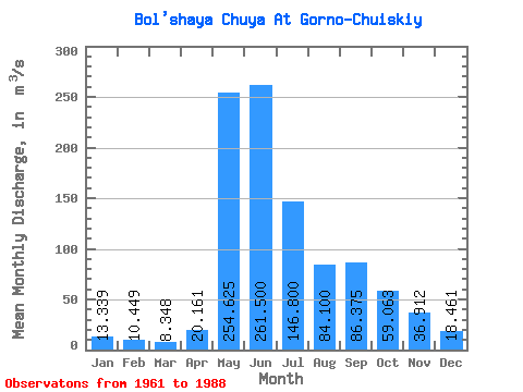
| Statistic | Jan | Feb | Mar | Apr | May | Jun | Jul | Aug | Sep | Oct | Nov | Dec | Annual |
|---|---|---|---|---|---|---|---|---|---|---|---|---|---|
| Mean | 13.34 | 10.45 | 8.35 | 20.16 | 254.62 | 261.50 | 146.80 | 84.10 | 86.38 | 59.06 | 36.91 | 18.46 | 83.34 |
| Standard Deviation | 4.34 | 2.59 | 2.87 | 21.24 | 85.16 | 106.12 | 52.02 | 24.00 | 27.08 | 12.22 | 14.35 | 6.12 | 9.90 |
| Min | 6.45 | 6.92 | 3.65 | 3.83 | 134.00 | 135.00 | 61.10 | 55.30 | 63.30 | 44.30 | 13.40 | 8.39 | 71.59 |
| Max | 19.60 | 15.10 | 12.00 | 65.70 | 374.00 | 417.00 | 207.00 | 122.00 | 148.00 | 75.10 | 56.30 | 28.40 | 101.70 |
| Coefficient of Variation | 0.33 | 0.25 | 0.34 | 1.05 | 0.33 | 0.41 | 0.35 | 0.28 | 0.31 | 0.21 | 0.39 | 0.33 | 0.12 |
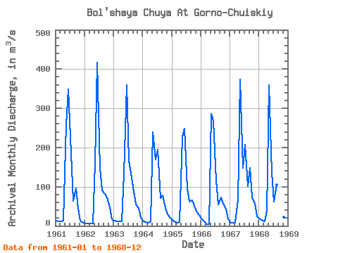
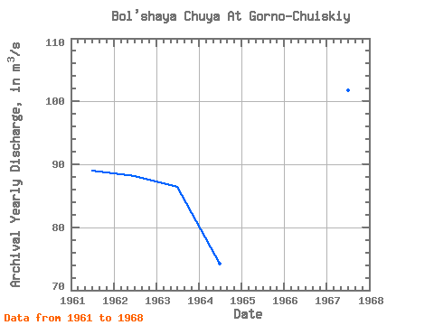
| Year | Jan | Feb | Mar | Apr | May | Jun | Jul | Aug | Sep | Oct | Nov | Dec | Annual | 1961 | 14.20 | 11.70 | 11.10 | 14.00 | 257.00 | 348.00 | 186.00 | 64.50 | 95.00 | 44.30 | 13.40 | 8.39 | 88.97 | 1962 | 6.45 | 6.92 | 5.75 | 5.96 | 160.00 | 417.00 | 147.00 | 90.90 | 81.50 | 71.80 | 48.00 | 16.30 | 88.13 | 1963 | 12.60 | 11.50 | 10.90 | 11.50 | 134.00 | 359.00 | 168.00 | 122.00 | 87.20 | 55.30 | 45.10 | 19.80 | 86.41 | 1964 | 12.30 | 9.03 | 7.33 | 11.40 | 240.00 | 169.00 | 195.00 | 71.40 | 78.50 | 46.40 | 29.20 | 21.10 | 74.22 | 1965 | 15.50 | 10.30 | 8.13 | 10.50 | 227.00 | 248.00 | 95.30 | 62.70 | 65.60 | 50.70 | 37.00 | 28.40 | 71.59 | 1966 | 19.60 | 11.30 | 3.65 | 3.83 | 285.00 | 268.00 | 115.00 | 55.30 | 71.90 | 57.20 | 44.00 | 16.30 | 79.26 | 1967 | 8.66 | 7.74 | 7.92 | 65.70 | 374.00 | 148.00 | 207.00 | 102.00 | 148.00 | 71.70 | 56.30 | 23.40 | 101.70 | 1968 | 17.40 | 15.10 | 12.00 | 38.40 | 360.00 | 135.00 | 61.10 | 104.00 | 63.30 | 75.10 | 22.30 | 14.00 | 76.47 | 1988 |
|---|
 Return to R-Arctic Net Home Page