|
|
|||||||||||||||||
| Point ID: 6155 | Downloads | Plots | Site Data | Code: 3071 |
|
|
|||||||||||||||||
| Download | |
|---|---|
| Site Descriptor Information | Site Time Series Data |
| Link to all available data | |
| View: | Time Series | All |
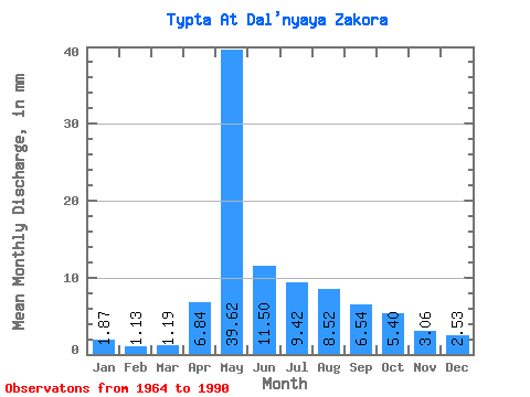
| Units: | m3/s |
| Statistic | Jan | Feb | Mar | Apr | May | Jun | Jul | Aug | Sep | Oct | Nov | Dec | Annual |
|---|---|---|---|---|---|---|---|---|---|---|---|---|---|
| Mean | 1.87 | 1.14 | 1.19 | 6.84 | 39.62 | 11.50 | 9.42 | 8.52 | 6.54 | 5.40 | 3.06 | 2.53 | 96.89 |
| Standard Deviation | 1.07 | 0.74 | 0.87 | 8.33 | 16.65 | 4.42 | 5.91 | 5.81 | 2.88 | 2.83 | 1.31 | 1.34 | 28.33 |
| Min | 0.66 | 0.26 | 0.11 | 1.53 | 13.60 | 2.96 | 2.49 | 2.26 | 2.67 | 2.23 | 1.26 | 1.07 | 40.58 |
| Max | 5.19 | 3.52 | 3.94 | 39.98 | 76.38 | 25.19 | 25.46 | 29.42 | 15.06 | 13.71 | 6.59 | 6.62 | 152.26 |
| Coefficient of Variation | 0.57 | 0.66 | 0.73 | 1.22 | 0.42 | 0.38 | 0.63 | 0.68 | 0.44 | 0.53 | 0.43 | 0.53 | 0.29 |
 Return to R-Arctic Net Home Page