|
|
|||||||||||||||||
| Point ID: 6073 | Downloads | Plots | Site Data | Code: 7187 |
|
|
|||||||||||||||||
| Download | |
|---|---|
| Site Descriptor Information | Site Time Series Data |
| Link to all available data | |
| View: | Time Series | All |
| Units: | m3/s |
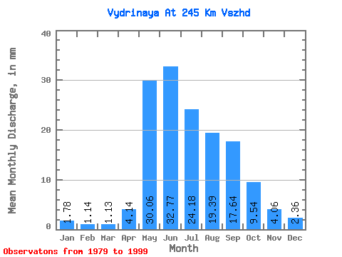
| Statistic | Jan | Feb | Mar | Apr | May | Jun | Jul | Aug | Sep | Oct | Nov | Dec | Annual |
|---|---|---|---|---|---|---|---|---|---|---|---|---|---|
| Mean | 1.78 | 1.15 | 1.13 | 4.14 | 30.05 | 32.77 | 24.18 | 19.39 | 17.64 | 9.54 | 4.06 | 2.36 | 147.55 |
| Standard Deviation | 0.45 | 0.38 | 0.38 | 3.33 | 7.00 | 12.09 | 15.51 | 8.96 | 6.02 | 2.76 | 1.43 | 0.75 | 21.93 |
| Min | 0.99 | 0.41 | 0.37 | 1.34 | 20.60 | 12.86 | 9.78 | 4.67 | 8.30 | 4.40 | 0.09 | 0.00 | 108.28 |
| Max | 3.01 | 1.87 | 1.74 | 14.55 | 43.05 | 54.23 | 72.92 | 45.73 | 33.50 | 15.55 | 7.00 | 3.87 | 185.07 |
| Coefficient of Variation | 0.25 | 0.33 | 0.34 | 0.80 | 0.23 | 0.37 | 0.64 | 0.46 | 0.34 | 0.29 | 0.35 | 0.32 | 0.15 |
 Return to R-Arctic Net Home Page