|
|
|||||||||||||||||
| Point ID: 6046 | Downloads | Plots | Site Data | Code: 7032 |
|
|
|||||||||||||||||
| Download | |
|---|---|
| Site Descriptor Information | Site Time Series Data |
| Link to all available data | |
| View: | Time Series | All |
| Units: | m3/s |
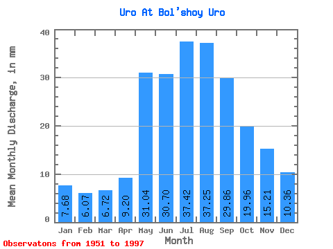
| Statistic | Jan | Feb | Mar | Apr | May | Jun | Jul | Aug | Sep | Oct | Nov | Dec | Annual |
|---|---|---|---|---|---|---|---|---|---|---|---|---|---|
| Mean | 7.68 | 6.12 | 6.72 | 9.20 | 31.04 | 30.70 | 37.41 | 37.25 | 29.86 | 19.95 | 15.21 | 10.36 | 240.54 |
| Standard Deviation | 2.52 | 2.19 | 2.62 | 4.37 | 13.11 | 14.70 | 22.83 | 18.82 | 15.27 | 7.59 | 10.43 | 3.33 | 74.01 |
| Min | 3.23 | 1.94 | 2.03 | 3.22 | 13.57 | 9.21 | 8.59 | 9.51 | 9.03 | 9.33 | 6.79 | 4.99 | 116.08 |
| Max | 15.24 | 12.03 | 13.21 | 29.32 | 96.96 | 97.42 | 122.82 | 96.96 | 88.84 | 46.36 | 70.07 | 19.21 | 442.57 |
| Coefficient of Variation | 0.33 | 0.36 | 0.39 | 0.47 | 0.42 | 0.48 | 0.61 | 0.51 | 0.51 | 0.38 | 0.69 | 0.32 | 0.31 |
 Return to R-Arctic Net Home Page