|
|
|||||||||||||||||
| Point ID: 5952 | Downloads | Plots | Site Data | Code: 1802 |
|
|
|||||||||||||||||
| Download | |
|---|---|
| Site Descriptor Information | Site Time Series Data |
| Link to all available data | |
|
|
| View: | Statistics | Time Series |
| Units: | mm |
| Statistic | Jan | Feb | Mar | Apr | May | Jun | Jul | Aug | Sep | Oct | Nov | Dec | Annual |
|---|---|---|---|---|---|---|---|---|---|---|---|---|---|
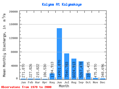
| Mean | 271.87 | 227.83 | 215.82 | 186.53 | 1784.91 | 14901.87 | 7540.78 | 6024.91 | 5267.48 | 1805.43 | 475.87 | 348.70 | 3254.33 |
| Standard Deviation | 100.23 | 112.19 | 120.57 | 109.45 | 1464.16 | 4844.23 | 3734.72 | 2174.86 | 2205.58 | 726.29 | 128.81 | 91.22 | 824.60 |
| Min | 127.00 | 58.50 | 43.50 | 30.60 | 141.00 | 7390.00 | 3254.00 | 2020.00 | 2260.00 | 942.00 | 294.00 | 199.00 | 1862.00 |
| Max | 555.00 | 486.00 | 483.00 | 405.00 | 5070.00 | 26201.00 | 17655.00 | 11787.00 | 10271.00 | 4220.00 | 838.00 | 522.00 | 4871.00 |
| Coefficient of Variation | 0.37 | 0.49 | 0.56 | 0.59 | 0.82 | 0.33 | 0.49 | 0.36 | 0.42 | 0.40 | 0.27 | 0.26 | 0.25 |
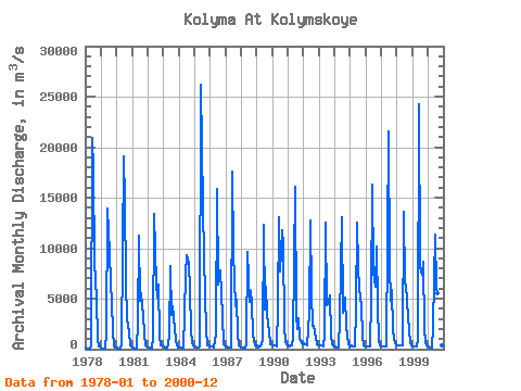
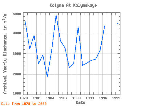
| Year | Jan | Feb | Mar | Apr | May | Jun | Jul | Aug | Sep | Oct | Nov | Dec | Annual | 1978 | 202.00 | 83.80 | 66.50 | 51.70 | 380.00 | 20948.00 | 17655.00 | 8687.00 | 4961.00 | 1058.00 | 318.00 | 240.00 | 4554.25 | 1979 | 156.00 | 58.50 | 43.50 | 30.60 | 1591.00 | 13905.00 | 9531.00 | 6463.00 | 4628.00 | 1822.00 | 294.00 | 199.00 | 3226.80 | 1980 | 144.00 | 83.70 | 67.70 | 43.20 | 487.00 | 19037.00 | 14632.00 | 6714.00 | 2995.00 | 1752.00 | 417.00 | 217.00 | 3882.47 | 1981 | 136.00 | 130.00 | 79.70 | 100.00 | 2708.00 | 11251.00 | 4749.00 | 5563.00 | 3272.00 | 1561.00 | 383.00 | 289.00 | 2518.47 | 1982 | 181.00 | 109.00 | 93.50 | 81.90 | 1279.00 | 13435.00 | 6447.00 | 5080.00 | 6363.00 | 1350.00 | 369.00 | 390.00 | 2931.53 | 1983 | 280.00 | 154.00 | 105.00 | 91.00 | 1266.00 | 8180.00 | 3409.00 | 4220.00 | 3147.00 | 942.00 | 340.00 | 210.00 | 1862.00 | 1984 | 127.00 | 161.00 | 152.00 | 94.80 | 3501.00 | 7390.00 | 9248.00 | 8599.00 | 5823.00 | 1838.00 | 597.00 | 370.00 | 3158.40 | 1985 | 267.00 | 177.00 | 163.00 | 140.00 | 295.00 | 26201.00 | 14043.00 | 9078.00 | 5464.00 | 1860.00 | 422.00 | 342.00 | 4871.00 | 1986 | 275.00 | 216.00 | 234.00 | 153.00 | 1611.00 | 15847.00 | 6365.00 | 6791.00 | 7829.00 | 3228.00 | 526.00 | 389.00 | 3622.00 | 1987 | 229.00 | 234.00 | 209.00 | 164.00 | 141.00 | 17566.00 | 9578.00 | 4220.00 | 4927.00 | 1591.00 | 396.00 | 259.00 | 3292.83 | 1988 | 184.00 | 143.00 | 100.00 | 100.00 | 590.00 | 9595.00 | 4676.00 | 5786.00 | 4490.00 | 1494.00 | 339.00 | 343.00 | 2320.00 | 1989 | 326.00 | 200.00 | 252.00 | 259.00 | 896.00 | 12283.00 | 3897.00 | 6214.00 | 3396.00 | 1752.00 | 520.00 | 463.00 | 2538.17 | 1990 | 368.00 | 337.00 | 328.00 | 295.00 | 4183.00 | 13058.00 | 7640.00 | 11787.00 | 10271.00 | 2277.00 | 681.00 | 514.00 | 4311.58 | 1991 | 372.00 | 291.00 | 338.00 | 335.00 | 1159.00 | 16076.00 | 3254.00 | 2020.00 | 3067.00 | 1135.00 | 549.00 | 522.00 | 2426.50 | 1992 | 555.00 | 486.00 | 483.00 | 405.00 | 3593.00 | 12788.00 | 5654.00 | 2314.00 | 2260.00 | 1104.00 | 474.00 | 417.00 | 2544.42 | 1993 | 341.00 | 330.00 | 323.00 | 289.00 | 1500.00 | 12563.00 | 4382.00 | 4709.00 | 5342.00 | 1388.00 | 496.00 | 344.00 | 2667.25 | 1994 | 295.00 | 213.00 | 215.00 | 175.00 | 2934.00 | 13020.00 | 3608.00 | 4118.00 | 5137.00 | 2283.00 | 440.00 | 303.00 | 2728.42 | 1995 | 270.00 | 400.00 | 290.00 | 251.00 | 4040.00 | 12500.00 | 8070.00 | 5950.00 | 4290.00 | 1210.00 | 412.00 | 306.00 | 3165.75 | 1996 | 281.00 | 299.00 | 322.00 | 225.00 | 5070.00 | 16300.00 | 7720.00 | 6200.00 | 10200.00 | 4220.00 | 838.00 | 382.00 | 4338.08 | 1997 | 275.00 | 253.00 | 281.00 | 269.00 | 261.00 | 21600.00 | 8280.00 | 4830.00 | 5850.00 | 1820.00 | 568.00 | 472.00 | 3729.92 | 1998 | 412.00 | 406.00 | 412.00 | 360.00 | 356.00 | 13600.00 | 6480.00 | 6370.00 | 3220.00 | 1840.00 | 548.00 | 372.00 | 2864.67 | 1999 | 311.00 | 268.00 | 266.00 | 270.00 | 952.00 | 24300.00 | 8110.00 | 7370.00 | 8690.00 | 2120.00 | 603.00 | 357.00 | 4468.08 | 2000 | 266.00 | 207.00 | 140.00 | 107.00 | 2260.00 | 11300.00 | 6010.00 | 5490.00 | 5530.00 | 1880.00 | 415.00 | 320.00 | 2827.08 |
|---|
 Return to R-Arctic Net Home Page