|
|
|||||||||||||||||
| Point ID: 5947 | Downloads | Plots | Site Data | Code: 1605 |
|
|
|||||||||||||||||
| Download | |
|---|---|
| Site Descriptor Information | Site Time Series Data |
| Link to all available data | |
|
|
| View: | Statistics | Time Series |
| Units: | mm |
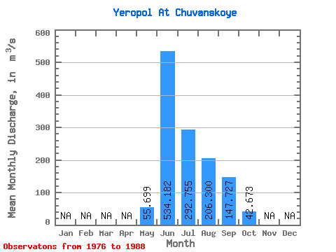
| Statistic | Jan | Feb | Mar | Apr | May | Jun | Jul | Aug | Sep | Oct | Nov | Dec | Annual |
|---|---|---|---|---|---|---|---|---|---|---|---|---|---|
| Mean | 55.70 | 534.18 | 292.75 | 206.30 | 147.73 | 42.67 | |||||||
| Standard Deviation | 45.20 | 144.57 | 151.89 | 99.25 | 110.96 | 32.75 | |||||||
| Min | 3.83 | 265.00 | 95.30 | 35.40 | 35.20 | 9.50 | |||||||
| Max | 130.00 | 730.00 | 541.00 | 326.00 | 369.00 | 106.00 | |||||||
| Coefficient of Variation | 0.81 | 0.27 | 0.52 | 0.48 | 0.75 | 0.77 |
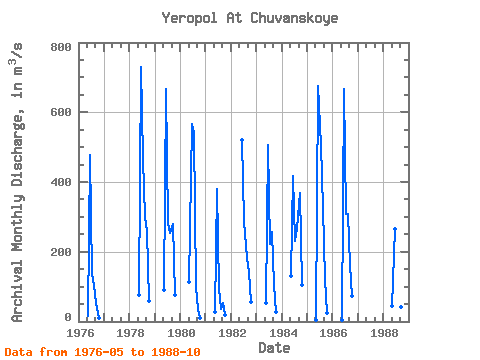
| Year | Jan | Feb | Mar | Apr | May | Jun | Jul | Aug | Sep | Oct | Nov | Dec | Annual | 1976 | 14.40 | 477.00 | 137.00 | 105.00 | 54.30 | 10.50 | 1978 | 75.00 | 730.00 | 466.00 | 299.00 | 259.00 | 60.00 | 1979 | 89.90 | 667.00 | 282.00 | 254.00 | 280.00 | 75.00 | 1980 | 114.00 | 567.00 | 541.00 | 97.90 | 35.20 | 9.50 | 1981 | 28.50 | 380.00 | 95.30 | 35.40 | 53.90 | 18.50 | 1982 | 521.00 | 287.00 | 182.00 | 143.00 | 56.50 | 1983 | 53.30 | 507.00 | 221.00 | 258.00 | 104.00 | 27.20 | 1984 | 130.00 | 418.00 | 232.00 | 267.00 | 369.00 | 106.00 | 1985 | 4.36 | 676.00 | 505.00 | 326.00 | 122.00 | 23.80 | 1986 | 3.83 | 668.00 | 308.00 | 308.00 | 163.00 | 71.70 | 1988 | 43.70 | 265.00 | 146.00 | 137.00 | 41.60 | 10.70 |
|---|
 Return to R-Arctic Net Home Page