|
|
|||||||||||||||||
| Point ID: 5944 | Downloads | Plots | Site Data | Code: 1597 |
|
|
|||||||||||||||||
| Download | |
|---|---|
| Site Descriptor Information | Site Time Series Data |
| Link to all available data | |
| View: | Time Series | All |
| Units: | m3/s |
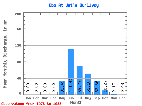
| Statistic | Jan | Feb | Mar | Apr | May | Jun | Jul | Aug | Sep | Oct | Nov | Dec | Annual |
|---|---|---|---|---|---|---|---|---|---|---|---|---|---|
| Mean | 0.00 | 0.00 | 0.00 | 0.00 | 33.49 | 111.47 | 69.76 | 51.09 | 32.66 | 10.27 | 2.17 | 0.47 | 305.87 |
| Standard Deviation | 0.00 | 0.00 | 0.00 | 0.00 | 18.87 | 68.79 | 35.27 | 18.53 | 19.42 | 4.55 | 2.17 | 0.62 | 80.19 |
| Min | 0.00 | 0.00 | 0.00 | 0.00 | 7.58 | 45.28 | 29.40 | 28.68 | 11.32 | 4.32 | 0.00 | 0.00 | 225.97 |
| Max | 0.00 | 0.00 | 0.00 | 0.00 | 54.85 | 279.89 | 135.51 | 91.95 | 77.29 | 21.98 | 5.74 | 1.69 | 472.44 |
| Coefficient of Variation | 0.56 | 0.62 | 0.51 | 0.36 | 0.59 | 0.44 | 1.00 | 1.31 | 0.26 |
 Return to R-Arctic Net Home Page