|
|
|||||||||||||||||
| Point ID: 5937 | Downloads | Plots | Site Data | Code: 1585 |
|
|
|||||||||||||||||
| Download | |
|---|---|
| Site Descriptor Information | Site Time Series Data |
| Link to all available data | |
|
|
| View: | Statistics | Time Series |
| Units: | mm |
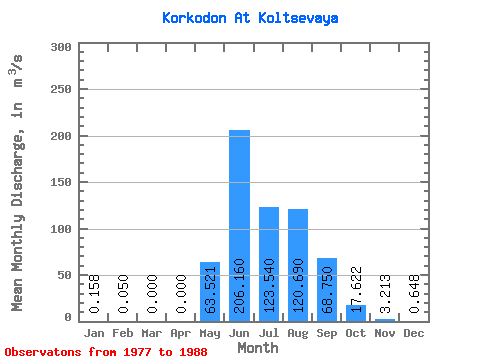
| Statistic | Jan | Feb | Mar | Apr | May | Jun | Jul | Aug | Sep | Oct | Nov | Dec | Annual |
|---|---|---|---|---|---|---|---|---|---|---|---|---|---|
| Mean | 0.16 | 0.05 | 0.00 | 0.00 | 63.52 | 206.16 | 123.54 | 120.69 | 68.75 | 17.62 | 3.21 | 0.65 | 51.29 |
| Standard Deviation | 0.26 | 0.09 | 0.00 | 0.00 | 36.61 | 85.18 | 69.61 | 59.86 | 23.28 | 6.73 | 2.71 | 0.63 | 13.93 |
| Min | 0.00 | 0.00 | 0.00 | 0.00 | 2.31 | 78.60 | 61.20 | 38.70 | 33.70 | 11.10 | 0.90 | 0.03 | 38.16 |
| Max | 0.55 | 0.15 | 0.00 | 0.00 | 127.00 | 353.00 | 305.00 | 209.00 | 104.00 | 29.30 | 8.85 | 1.63 | 65.90 |
| Coefficient of Variation | 1.66 | 1.73 | 0.58 | 0.41 | 0.56 | 0.50 | 0.34 | 0.38 | 0.84 | 0.97 | 0.27 |
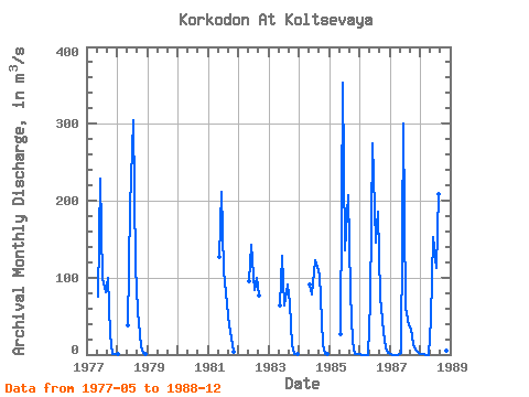
| Year | Jan | Feb | Mar | Apr | May | Jun | Jul | Aug | Sep | Oct | Nov | Dec | Annual | 1977 | 75.20 | 228.00 | 98.10 | 81.50 | 99.00 | 26.90 | 1.38 | 0.24 | 1978 | 0.00 | 37.30 | 192.00 | 305.00 | 115.00 | 57.10 | 11.10 | 1.89 | 0.85 | 1981 | 127.00 | 211.00 | 108.00 | 65.20 | 37.80 | 21.70 | 3.18 | 1982 | 95.70 | 143.00 | 83.20 | 99.00 | 77.10 | 1983 | 63.70 | 128.00 | 63.90 | 91.50 | 66.00 | 11.80 | 0.90 | 0.03 | 1984 | 90.90 | 78.60 | 122.00 | 114.00 | 104.00 | 13.70 | 1.43 | 0.07 | 1985 | 26.40 | 353.00 | 136.00 | 207.00 | 80.40 | 16.60 | 1.03 | 0.21 | 1986 | 0.06 | 0.00 | 0.00 | 0.00 | 69.50 | 275.00 | 145.00 | 186.00 | 75.50 | 29.30 | 8.85 | 1.63 | 65.90 | 1987 | 0.02 | 0.00 | 0.00 | 0.00 | 2.31 | 301.00 | 61.20 | 38.70 | 33.70 | 13.60 | 5.87 | 1.47 | 38.16 | 1988 | 0.55 | 0.15 | 0.00 | 0.00 | 47.20 | 152.00 | 113.00 | 209.00 | 56.90 | 13.90 | 4.39 | 0.68 | 49.81 |
|---|
 Return to R-Arctic Net Home Page