|
|
|||||||||||||||||
| Point ID: 5919 | Downloads | Plots | Site Data | Code: 1501 |
|
|
|||||||||||||||||
| Download | |
|---|---|
| Site Descriptor Information | Site Time Series Data |
| Link to all available data | |
| View: | Time Series | All |
| Units: | m3/s |
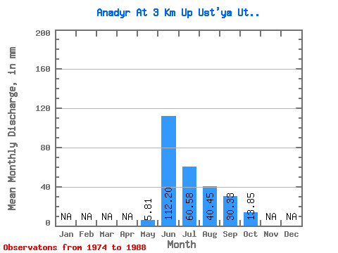
| Statistic | Jan | Feb | Mar | Apr | May | Jun | Jul | Aug | Sep | Oct | Nov | Dec | Annual |
|---|---|---|---|---|---|---|---|---|---|---|---|---|---|
| Mean | 5.81 | 112.20 | 60.57 | 40.44 | 30.33 | 13.85 | |||||||
| Standard Deviation | 3.84 | 29.21 | 30.10 | 13.12 | 11.30 | 5.36 | |||||||
| Min | 1.05 | 64.63 | 31.93 | 17.17 | 17.61 | 7.66 | |||||||
| Max | 11.67 | 160.84 | 142.48 | 58.37 | 47.85 | 25.23 | |||||||
| Coefficient of Variation | 0.66 | 0.26 | 0.50 | 0.32 | 0.37 | 0.39 |
 Return to R-Arctic Net Home Page