|
|
|||||||||||||||||
| Point ID: 5919 | Downloads | Plots | Site Data | Code: 1501 |
|
|
|||||||||||||||||
| Download | |
|---|---|
| Site Descriptor Information | Site Time Series Data |
| Link to all available data | |
|
|
| View: | Statistics | Time Series |
| Units: | mm |
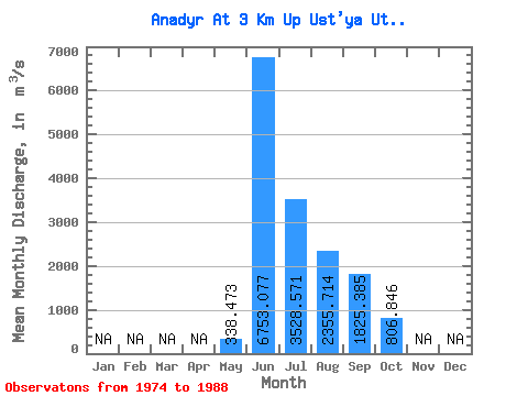
| Statistic | Jan | Feb | Mar | Apr | May | Jun | Jul | Aug | Sep | Oct | Nov | Dec | Annual |
|---|---|---|---|---|---|---|---|---|---|---|---|---|---|
| Mean | 338.47 | 6753.08 | 3528.57 | 2355.71 | 1825.38 | 806.85 | |||||||
| Standard Deviation | 223.97 | 1757.97 | 1753.29 | 764.21 | 680.24 | 312.00 | |||||||
| Min | 61.20 | 3890.00 | 1860.00 | 1000.00 | 1060.00 | 446.00 | |||||||
| Max | 680.00 | 9680.00 | 8300.00 | 3400.00 | 2880.00 | 1470.00 | |||||||
| Coefficient of Variation | 0.66 | 0.26 | 0.50 | 0.32 | 0.37 | 0.39 |
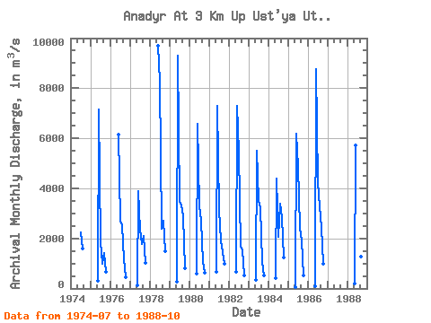
| Year | Jan | Feb | Mar | Apr | May | Jun | Jul | Aug | Sep | Oct | Nov | Dec | Annual | 1974 | 2230.00 | 1580.00 | 1975 | 309.00 | 7150.00 | 1860.00 | 1000.00 | 1420.00 | 660.00 | 1976 | 6130.00 | 2700.00 | 2530.00 | 1170.00 | 446.00 | 1977 | 119.00 | 3890.00 | 2330.00 | 1770.00 | 2080.00 | 1010.00 | 1978 | 9680.00 | 8300.00 | 2400.00 | 2690.00 | 1470.00 | 1979 | 275.00 | 9300.00 | 3450.00 | 3320.00 | 2880.00 | 811.00 | 1980 | 580.00 | 6560.00 | 3290.00 | 2690.00 | 1060.00 | 642.00 | 1981 | 672.00 | 7280.00 | 3130.00 | 1930.00 | 1440.00 | 994.00 | 1982 | 680.00 | 7280.00 | 5450.00 | 1680.00 | 1520.00 | 530.00 | 1983 | 329.00 | 5490.00 | 3510.00 | 3230.00 | 1060.00 | 528.00 | 1984 | 412.00 | 4390.00 | 2050.00 | 3400.00 | 2800.00 | 1230.00 | 1985 | 61.20 | 6170.00 | 4840.00 | 2410.00 | 1920.00 | 512.00 | 1986 | 101.00 | 8770.00 | 4240.00 | 3290.00 | 2420.00 | 989.00 | 1988 | 185.00 | 5700.00 | 2020.00 | 1750.00 | 1270.00 | 667.00 |
|---|
 Return to R-Arctic Net Home Page