|
|
|||||||||||||||||
| Point ID: 5915 | Downloads | Plots | Site Data | Code: 1494 |
|
|
|||||||||||||||||
| Download | |
|---|---|
| Site Descriptor Information | Site Time Series Data |
| Link to all available data | |
| View: | Time Series | All |
| Units: | m3/s |
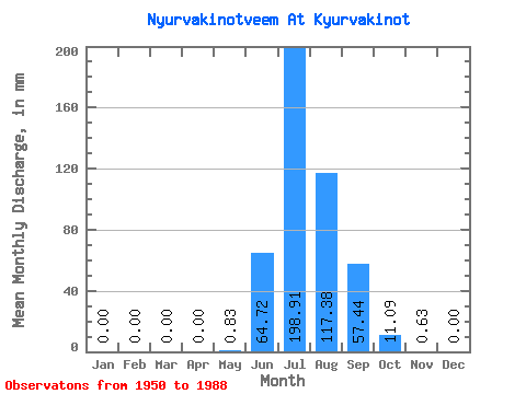
| Statistic | Jan | Feb | Mar | Apr | May | Jun | Jul | Aug | Sep | Oct | Nov | Dec | Annual |
|---|---|---|---|---|---|---|---|---|---|---|---|---|---|
| Mean | 0.00 | 0.00 | 0.00 | 0.00 | 0.82 | 64.73 | 198.88 | 117.36 | 57.43 | 11.08 | 0.63 | 0.00 | 257.57 |
| Standard Deviation | 0.00 | 0.00 | 0.00 | 0.00 | 1.28 | 66.78 | 99.22 | 59.53 | 45.18 | 11.69 | 1.08 | 0.00 | 78.04 |
| Min | 0.00 | 0.00 | 0.00 | 0.00 | 0.00 | 0.66 | 59.90 | 46.96 | 6.64 | 0.25 | 0.00 | 0.00 | 197.10 |
| Max | 0.00 | 0.00 | 0.00 | 0.00 | 4.27 | 255.44 | 439.87 | 379.06 | 222.89 | 45.41 | 2.75 | 0.00 | 345.66 |
| Coefficient of Variation | 1.56 | 1.03 | 0.50 | 0.51 | 0.79 | 1.05 | 1.72 | 0.30 |
 Return to R-Arctic Net Home Page