|
|
|||||||||||||||||
| Point ID: 5847 | Downloads | Plots | Site Data | Code: 10MA001 |
|
|
|||||||||||||||||
| Download | |
|---|---|
| Site Descriptor Information | Site Time Series Data |
| Link to all available data | |
|
|
| View: | Statistics | Time Series |
| Units: | mm |
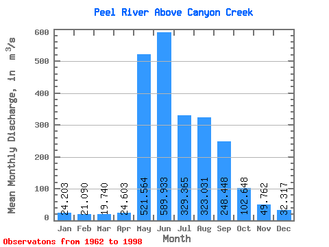
| Statistic | Jan | Feb | Mar | Apr | May | Jun | Jul | Aug | Sep | Oct | Nov | Dec | Annual |
|---|---|---|---|---|---|---|---|---|---|---|---|---|---|
| Mean | 24.20 | 21.09 | 19.74 | 24.60 | 521.56 | 589.93 | 329.37 | 323.03 | 248.45 | 102.65 | 49.76 | 32.32 | 187.20 |
| Standard Deviation | 4.70 | 4.14 | 3.77 | 15.28 | 271.70 | 180.26 | 177.96 | 131.63 | 83.38 | 30.84 | 14.32 | 6.92 | 41.99 |
| Min | 13.00 | 12.80 | 12.30 | 12.60 | 72.90 | 304.00 | 98.30 | 108.00 | 77.80 | 50.60 | 26.10 | 15.70 | 114.28 |
| Max | 32.30 | 29.00 | 26.90 | 93.40 | 1300.00 | 1120.00 | 948.00 | 658.00 | 424.00 | 184.00 | 102.00 | 48.20 | 317.68 |
| Coefficient of Variation | 0.19 | 0.20 | 0.19 | 0.62 | 0.52 | 0.31 | 0.54 | 0.41 | 0.34 | 0.30 | 0.29 | 0.21 | 0.22 |
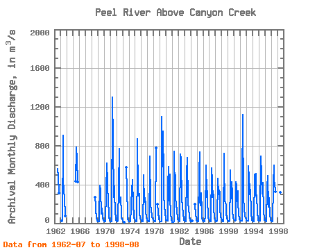
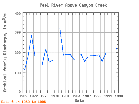
| Year | Jan | Feb | Mar | Apr | May | Jun | Jul | Aug | Sep | Oct | Nov | Dec | Annual | 1962 | 562.00 | 486.00 | 309.00 | 1963 | 24.40 | 24.40 | 26.20 | 905.00 | 445.00 | 332.00 | 266.00 | 77.80 | 1965 | 437.00 | 785.00 | 658.00 | 424.00 | 1968 | 266.00 | 190.00 | 138.00 | 50.60 | 26.10 | 20.00 | 1969 | 16.90 | 16.40 | 16.20 | 58.40 | 390.00 | 341.00 | 98.30 | 160.00 | 154.00 | 53.40 | 33.20 | 33.60 | 114.28 | 1970 | 21.20 | 15.90 | 15.70 | 16.00 | 316.00 | 618.00 | 427.00 | 353.00 | 258.00 | 70.20 | 33.90 | 25.50 | 180.87 | 1971 | 19.30 | 17.90 | 18.30 | 17.10 | 1300.00 | 839.00 | 266.00 | 449.00 | 319.00 | 109.00 | 51.60 | 31.90 | 286.51 | 1972 | 22.00 | 19.50 | 20.80 | 22.30 | 373.00 | 774.00 | 218.00 | 235.00 | 268.00 | 102.00 | 52.00 | 36.60 | 178.60 | 1973 | 24.50 | 16.50 | 12.30 | 12.60 | 574.00 | 330.00 | 114.00 | 43.90 | 27.80 | 1974 | 18.30 | 15.20 | 15.50 | 16.80 | 156.00 | 393.00 | 280.00 | 451.00 | 197.00 | 73.90 | 50.30 | 40.00 | 142.25 | 1975 | 25.90 | 20.10 | 18.40 | 21.10 | 534.00 | 874.00 | 335.00 | 286.00 | 302.00 | 108.00 | 47.80 | 37.50 | 217.48 | 1976 | 28.00 | 19.90 | 16.10 | 15.80 | 363.00 | 499.00 | 216.00 | 261.00 | 199.00 | 122.00 | 63.10 | 31.90 | 152.90 | 1977 | 25.40 | 21.90 | 17.30 | 19.30 | 594.00 | 694.00 | 210.00 | 108.00 | 103.00 | 70.20 | 46.70 | 33.90 | 161.97 | 1978 | 25.80 | 22.30 | 20.00 | 19.10 | 75.90 | 775.00 | 196.00 | 109.00 | 39.40 | 26.50 | 1979 | 21.60 | 17.40 | 19.40 | 21.50 | 1100.00 | 584.00 | 948.00 | 479.00 | 287.00 | 184.00 | 102.00 | 48.20 | 317.68 | 1980 | 31.30 | 28.70 | 26.70 | 24.90 | 380.00 | 581.00 | 236.00 | 506.00 | 270.00 | 103.00 | 34.50 | 15.70 | 186.48 | 1981 | 13.00 | 12.80 | 14.30 | 15.70 | 744.00 | 304.00 | 501.00 | 258.00 | 207.00 | 123.00 | 63.90 | 36.90 | 191.13 | 1982 | 22.90 | 22.60 | 21.40 | 20.90 | 716.00 | 665.00 | 216.00 | 247.00 | 178.00 | 97.90 | 48.20 | 32.20 | 190.68 | 1983 | 25.40 | 24.00 | 23.00 | 21.40 | 502.00 | 681.00 | 203.00 | 193.00 | 163.00 | 70.20 | 34.50 | 22.00 | 163.54 | 1984 | 18.50 | 17.10 | 18.40 | 28.30 | 195.00 | 89.40 | 47.80 | 28.80 | 1985 | 19.40 | 18.70 | 20.00 | 20.50 | 527.00 | 736.00 | 229.00 | 185.00 | 313.00 | 135.00 | 61.50 | 25.50 | 190.88 | 1986 | 22.30 | 21.00 | 19.90 | 20.00 | 72.90 | 598.00 | 271.00 | 447.00 | 218.00 | 89.70 | 50.70 | 36.70 | 155.60 | 1987 | 28.10 | 22.10 | 18.70 | 18.90 | 572.00 | 433.00 | 267.00 | 335.00 | 266.00 | 152.00 | 52.90 | 32.70 | 183.20 | 1988 | 24.70 | 20.90 | 18.10 | 23.70 | 453.00 | 463.00 | 296.00 | 343.00 | 318.00 | 146.00 | 68.60 | 43.20 | 184.85 | 1989 | 31.70 | 26.30 | 18.30 | 19.30 | 723.00 | 594.00 | 223.00 | 218.00 | 186.00 | 103.00 | 52.30 | 31.60 | 185.54 | 1990 | 24.40 | 20.50 | 18.90 | 21.60 | 406.00 | 547.00 | 256.00 | 429.00 | 308.00 | 135.00 | 53.40 | 38.00 | 188.15 | 1991 | 32.30 | 29.00 | 26.90 | 31.50 | 423.00 | 387.00 | 227.00 | 333.00 | 214.00 | 100.00 | 41.60 | 30.60 | 156.32 | 1992 | 27.90 | 26.20 | 25.10 | 24.70 | 430.00 | 1120.00 | 223.00 | 188.00 | 156.00 | 65.40 | 55.60 | 38.40 | 198.36 | 1993 | 29.50 | 25.40 | 25.30 | 26.50 | 592.00 | 467.00 | 346.00 | 242.00 | 348.00 | 112.00 | 33.60 | 26.50 | 189.48 | 1994 | 21.70 | 19.80 | 18.90 | 26.10 | 504.00 | 483.00 | 511.00 | 284.00 | 287.00 | 101.00 | 50.00 | 34.20 | 195.06 | 1995 | 28.30 | 26.30 | 26.10 | 93.40 | 689.00 | 493.00 | 345.00 | 302.00 | 422.00 | 121.00 | 48.70 | 35.40 | 219.18 | 1996 | 28.80 | 25.60 | 21.20 | 16.00 | 368.00 | 488.00 | 170.00 | 250.00 | 263.00 | 66.90 | 55.30 | 35.40 | 149.02 | 1997 | 22.80 | 18.30 | 16.60 | 18.50 | 395.00 | 600.00 | 428.00 | 413.00 | 325.00 | 1998 | 785.00 | 319.00 | 208.00 |
|---|
 Return to R-Arctic Net Home Page