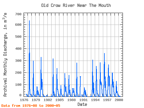
| Point ID: 5836 | Downloads | Plots | Site Data | Other Close Sites | Code: 09FC001 |
| Download | |
|---|---|
| Site Descriptor Information | Site Time Series Data |
| Link to all available data | |

|

|
| View: | Statistics | Time Series |
| Units: | mm |
| Statistic | Jan | Feb | Mar | Apr | May | Jun | Jul | Aug | Sep | Oct | Nov | Dec | Annual |
|---|---|---|---|---|---|---|---|---|---|---|---|---|---|
| Mean | 1.17 | 0.74 | 0.62 | 0.71 | 104.64 | 236.78 | 55.39 | 52.11 | 55.09 | 15.47 | 5.59 | 2.42 | 45.26 |
| Standard Deviation | 0.82 | 0.54 | 0.40 | 0.35 | 84.46 | 135.60 | 28.26 | 47.17 | 44.61 | 12.14 | 5.13 | 1.90 | 20.07 |
| Min | 0.10 | 0.02 | 0.02 | 0.00 | 1.26 | 53.70 | 11.90 | 8.27 | 4.67 | 1.73 | 0.34 | 0.12 | 15.03 |
| Max | 3.95 | 2.19 | 1.32 | 1.21 | 282.00 | 634.00 | 96.30 | 165.00 | 167.00 | 52.10 | 23.30 | 8.31 | 74.88 |
| Coefficient of Variation | 0.70 | 0.73 | 0.64 | 0.49 | 0.81 | 0.57 | 0.51 | 0.91 | 0.81 | 0.79 | 0.92 | 0.79 | 0.44 |
| Year | Jan | Feb | Mar | Apr | May | Jun | Jul | Aug | Sep | Oct | Nov | Dec | Annual | 1976 | 18.40 | 19.00 | 10.70 | 6.12 | 3.42 | 1977 | 1.95 | 1.21 | 1.16 | 1.21 | 81.40 | 634.00 | 96.30 | 23.10 | 17.20 | 17.60 | 5.37 | 2.20 | 73.56 | 1978 | 1.29 | 1.05 | 0.99 | 0.92 | 13.80 | 298.00 | 80.30 | 14.00 | 9.35 | 8.03 | 3.60 | 2.03 | 36.11 | 1979 | 0.98 | 0.58 | 0.61 | 0.75 | 81.20 | 79.10 | 18.40 | 9.49 | 45.20 | 22.90 | 8.55 | 2.49 | 22.52 | 1980 | 0.81 | 0.57 | 0.50 | 0.47 | 119.00 | 328.00 | 57.00 | 145.00 | 97.60 | 22.20 | 8.09 | 2.88 | 65.18 | 1981 | 1.41 | 0.85 | 0.76 | 0.80 | 7.09 | 5.11 | 1983 | 0.69 | 0.13 | 0.13 | 0.54 | 12.10 | 316.00 | 49.00 | 8.82 | 38.40 | 6.55 | 1.28 | 0.48 | 36.18 | 1984 | 0.24 | 0.07 | 0.04 | 0.06 | 137.00 | 235.00 | 57.70 | 63.40 | 48.00 | 14.70 | 1.86 | 0.90 | 46.58 | 1985 | 0.72 | 0.60 | 0.54 | 0.48 | 31.00 | 92.20 | 31.80 | 8.27 | 7.68 | 4.37 | 1.79 | 0.91 | 15.03 | 1986 | 0.28 | 0.02 | 0.09 | 0.27 | 2.67 | 192.00 | 38.40 | 55.80 | 81.10 | 8.28 | 2.47 | 1.51 | 31.91 | 1987 | 1.06 | 0.88 | 0.80 | 0.72 | 115.00 | 177.00 | 15.80 | 40.90 | 53.90 | 11.00 | 3.19 | 1.29 | 35.13 | 1988 | 0.82 | 0.72 | 0.72 | 1.03 | 63.10 | 35.70 | 67.50 | 15.20 | 2.40 | 1.01 | 1989 | 0.70 | 0.53 | 0.41 | 0.34 | 15.10 | 281.00 | 44.10 | 14.20 | 4.67 | 1.73 | 1.24 | 0.89 | 30.41 | 1990 | 0.83 | 0.79 | 0.66 | 0.44 | 165.00 | 12.30 | 2.51 | 0.34 | 0.12 | 1991 | 0.10 | 0.07 | 0.02 | 0.00 | 74.00 | 53.70 | 11.90 | 52.30 | 11.80 | 2.59 | 0.93 | 0.34 | 17.31 | 1993 | 0.73 | 0.59 | 0.63 | 0.82 | 106.00 | 306.00 | 41.80 | 25.50 | 115.00 | 21.20 | 9.17 | 3.49 | 52.58 | 1994 | 1.29 | 0.15 | 0.20 | 1.06 | 252.00 | 202.00 | 79.50 | 22.20 | 26.00 | 8.38 | 3.79 | 1.96 | 49.88 | 1995 | 1.26 | 0.95 | 0.80 | 0.86 | 282.00 | 118.00 | 96.10 | 121.00 | 87.20 | 34.40 | 12.70 | 4.70 | 63.33 | 1996 | 1.65 | 0.65 | 0.31 | 0.70 | 183.00 | 360.00 | 73.20 | 165.00 | 85.00 | 17.30 | 8.39 | 3.31 | 74.88 | 1997 | 1.10 | 0.53 | 0.54 | 0.99 | 213.00 | 265.00 | 86.90 | 105.00 | 167.00 | 28.90 | 6.81 | 3.44 | 73.27 | 1998 | 2.26 | 1.62 | 1.19 | 1.11 | 198.00 | 198.00 | 88.30 | 75.60 | 121.00 | 52.10 | 23.30 | 8.31 | 64.23 | 1999 | 3.95 | 2.19 | 1.32 | 0.94 | 51.70 | 127.00 | 30.60 | 38.60 | 41.90 | 14.20 | 4.40 | 2.53 | 26.61 | 2000 | 1.69 | 1.44 | 1.28 | 1.19 | 1.26 |
|---|
| Other Close Sites | ||||||
|---|---|---|---|---|---|---|
| PointID | Latitude | Longitude | Drainage Area | Source | Name | |
| 5837 | "PORCUPINE RIVER AT OLD CROW" | 67.56 | 1895978 | Hydat | ||
 Return to R-Arctic Net Home Page