|
|
|||||||||||||||||
| Point ID: 5824 | Downloads | Plots | Site Data | Code: 09EA003 |
|
|
|||||||||||||||||
| Download | |
|---|---|
| Site Descriptor Information | Site Time Series Data |
| Link to all available data | |
|
|
| View: | Statistics | Time Series |
| Units: | mm |
| Statistic | Jan | Feb | Mar | Apr | May | Jun | Jul | Aug | Sep | Oct | Nov | Dec | Annual |
|---|---|---|---|---|---|---|---|---|---|---|---|---|---|
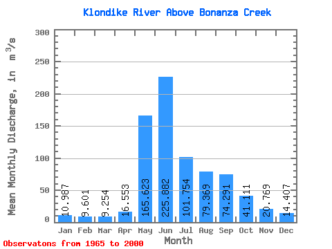
| Mean | 10.99 | 9.60 | 9.25 | 16.55 | 165.62 | 225.88 | 101.75 | 79.37 | 74.29 | 41.11 | 20.77 | 14.41 | 63.68 |
| Standard Deviation | 2.31 | 1.80 | 2.00 | 9.76 | 43.27 | 65.59 | 42.39 | 30.84 | 27.92 | 13.18 | 4.84 | 3.78 | 12.39 |
| Min | 6.25 | 4.95 | 4.85 | 6.07 | 66.20 | 129.00 | 38.60 | 31.10 | 37.10 | 23.80 | 13.10 | 7.97 | 39.27 |
| Max | 19.80 | 13.70 | 12.90 | 45.30 | 243.00 | 404.00 | 229.00 | 141.00 | 157.00 | 69.40 | 31.60 | 26.30 | 97.53 |
| Coefficient of Variation | 0.21 | 0.19 | 0.22 | 0.59 | 0.26 | 0.29 | 0.42 | 0.39 | 0.38 | 0.32 | 0.23 | 0.26 | 0.20 |
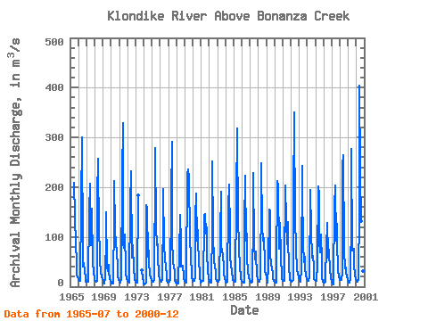
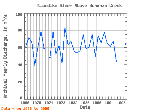
| Year | Jan | Feb | Mar | Apr | May | Jun | Jul | Aug | Sep | Oct | Nov | Dec | Annual | 1965 | 208.00 | 141.00 | 85.90 | 48.70 | 21.80 | 20.50 | 1966 | 12.60 | 11.20 | 10.90 | 13.60 | 166.00 | 301.00 | 76.30 | 39.60 | 46.60 | 31.50 | 17.00 | 10.60 | 61.41 | 1967 | 9.87 | 9.46 | 9.06 | 10.50 | 150.00 | 207.00 | 83.90 | 127.00 | 157.00 | 51.40 | 26.00 | 18.10 | 71.61 | 1968 | 14.10 | 11.30 | 10.10 | 11.90 | 183.00 | 258.00 | 102.00 | 79.20 | 52.50 | 27.80 | 21.40 | 15.20 | 65.54 | 1969 | 11.50 | 8.31 | 6.33 | 19.10 | 105.00 | 150.00 | 38.60 | 31.10 | 44.20 | 29.40 | 14.50 | 13.20 | 39.27 | 1970 | 8.51 | 6.59 | 5.48 | 6.07 | 138.00 | 213.00 | 115.00 | 83.10 | 72.70 | 38.70 | 22.90 | 12.80 | 60.24 | 1971 | 9.00 | 8.75 | 9.15 | 12.90 | 222.00 | 329.00 | 84.50 | 78.00 | 105.00 | 39.10 | 24.10 | 16.30 | 78.15 | 1972 | 11.10 | 9.22 | 8.15 | 8.44 | 165.00 | 232.00 | 57.40 | 65.80 | 82.50 | 35.70 | 18.40 | 13.00 | 58.89 | 1973 | 9.84 | 8.37 | 7.99 | 9.56 | 184.00 | 33.40 | 16.00 | 11.20 | 1974 | 6.25 | 4.95 | 5.39 | 7.64 | 164.00 | 156.00 | 60.40 | 72.10 | 50.60 | 23.80 | 16.20 | 14.00 | 48.44 | 1975 | 9.89 | 9.54 | 10.10 | 12.60 | 239.00 | 279.00 | 120.00 | 83.50 | 85.90 | 59.60 | 24.10 | 14.90 | 79.01 | 1976 | 12.60 | 10.80 | 9.76 | 15.00 | 151.00 | 196.00 | 83.40 | 56.00 | 37.80 | 26.40 | 13.90 | 7.97 | 51.72 | 1977 | 10.10 | 10.20 | 9.06 | 13.60 | 181.00 | 292.00 | 94.70 | 51.00 | 38.30 | 31.10 | 13.10 | 8.45 | 62.72 | 1978 | 8.00 | 7.11 | 6.91 | 11.40 | 66.20 | 145.00 | 88.70 | 40.00 | 42.50 | 42.50 | 22.90 | 17.60 | 41.57 | 1979 | 12.10 | 8.08 | 8.76 | 12.70 | 226.00 | 235.00 | 219.00 | 98.20 | 90.60 | 64.70 | 20.70 | 10.30 | 83.84 | 1980 | 9.95 | 11.20 | 12.20 | 18.40 | 139.00 | 188.00 | 92.00 | 113.00 | 86.70 | 57.00 | 20.90 | 8.69 | 63.09 | 1981 | 9.32 | 9.58 | 11.40 | 10.80 | 131.00 | 144.00 | 146.00 | 107.00 | 119.00 | 69.40 | 31.60 | 18.80 | 67.33 | 1982 | 10.20 | 9.02 | 8.41 | 8.32 | 124.00 | 252.00 | 109.00 | 49.00 | 44.50 | 26.70 | 17.20 | 12.30 | 55.89 | 1983 | 10.10 | 10.30 | 9.76 | 13.90 | 106.00 | 190.00 | 80.00 | 74.60 | 62.50 | 40.60 | 25.40 | 16.20 | 53.28 | 1984 | 9.09 | 8.46 | 10.30 | 15.90 | 159.00 | 205.00 | 108.00 | 54.70 | 47.90 | 28.60 | 17.00 | 13.90 | 56.49 | 1985 | 11.40 | 9.09 | 9.50 | 10.20 | 181.00 | 318.00 | 122.00 | 93.70 | 74.70 | 44.20 | 16.90 | 11.90 | 75.22 | 1986 | 11.30 | 9.67 | 7.74 | 8.14 | 123.00 | 223.00 | 92.00 | 106.00 | 58.20 | 31.00 | 19.10 | 12.90 | 58.50 | 1987 | 10.80 | 9.50 | 8.03 | 10.50 | 141.00 | 228.00 | 84.10 | 55.50 | 70.20 | 67.10 | 22.60 | 16.00 | 60.28 | 1988 | 12.20 | 10.50 | 10.30 | 18.80 | 193.00 | 249.00 | 121.00 | 92.10 | 97.20 | 48.10 | 30.60 | 26.30 | 75.76 | 1989 | 19.80 | 11.80 | 8.78 | 39.60 | 155.00 | 152.00 | 65.60 | 45.70 | 37.10 | 28.00 | 17.10 | 11.90 | 49.37 | 1990 | 9.72 | 8.12 | 7.19 | 29.10 | 213.00 | 202.00 | 76.00 | 115.00 | 128.00 | 61.80 | 20.80 | 14.60 | 73.78 | 1991 | 12.30 | 11.20 | 11.10 | 35.00 | 203.00 | 134.00 | 85.50 | 130.00 | 89.80 | 43.50 | 13.20 | 14.20 | 65.23 | 1992 | 11.50 | 10.60 | 11.70 | 13.70 | 174.00 | 350.00 | 124.00 | 88.40 | 75.80 | 32.30 | 25.90 | 18.50 | 78.03 | 1993 | 14.30 | 11.50 | 10.40 | 36.70 | 243.00 | 195.00 | 85.50 | 49.80 | 60.70 | 36.00 | 21.80 | 14.70 | 64.95 | 1994 | 12.20 | 11.60 | 11.60 | 18.70 | 184.00 | 194.00 | 113.00 | 57.80 | 61.40 | 41.00 | 15.40 | 12.90 | 61.13 | 1995 | 12.40 | 12.20 | 12.50 | 45.30 | 201.00 | 185.00 | 89.90 | 69.20 | 104.00 | 53.00 | 16.20 | 9.63 | 67.53 | 1996 | 8.38 | 8.49 | 9.69 | 15.00 | 80.60 | 129.00 | 69.60 | 58.10 | 74.10 | 28.60 | 24.20 | 17.90 | 43.64 | 1997 | 10.20 | 6.53 | 4.85 | 8.98 | 161.00 | 204.00 | 91.40 | 127.00 | 94.90 | 29.20 | 22.10 | 13.70 | 64.49 | 1998 | 12.60 | 13.70 | 12.90 | 29.50 | 243.00 | 265.00 | 73.60 | 37.50 | 51.50 | 27.30 | 23.20 | 13.90 | 66.97 | 1999 | 9.62 | 8.69 | 8.68 | 14.50 | 145.00 | 276.00 | 72.30 | 76.20 | 75.60 | 44.80 | 22.90 | 15.30 | 64.13 | 2000 | 11.70 | 10.40 | 9.71 | 13.30 | 157.00 | 404.00 | 229.00 | 132.00 | 94.30 | 58.00 | 30.60 | 20.30 | 97.53 |
|---|
 Return to R-Arctic Net Home Page