|
|
|||||||||||||||||
| Point ID: 5820 | Downloads | Plots | Site Data | Code: 09DC003 |
|
|
|||||||||||||||||
| Download | |
|---|---|
| Site Descriptor Information | Site Time Series Data |
| Link to all available data | |
|
|
| View: | Statistics | Time Series |
| Units: | mm |
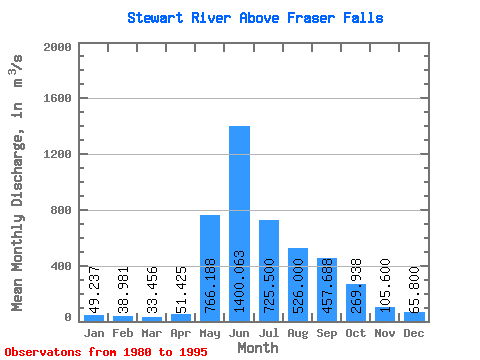
| Statistic | Jan | Feb | Mar | Apr | May | Jun | Jul | Aug | Sep | Oct | Nov | Dec | Annual |
|---|---|---|---|---|---|---|---|---|---|---|---|---|---|
| Mean | 49.24 | 38.98 | 33.46 | 51.42 | 766.19 | 1400.06 | 725.50 | 526.00 | 457.69 | 269.94 | 105.60 | 65.80 | 374.16 |
| Standard Deviation | 10.59 | 7.76 | 5.84 | 25.83 | 243.58 | 433.03 | 184.49 | 147.65 | 188.89 | 90.09 | 21.94 | 12.36 | 56.49 |
| Min | 24.80 | 24.40 | 20.70 | 25.90 | 433.00 | 733.00 | 441.00 | 240.00 | 181.00 | 130.00 | 71.80 | 46.90 | 292.28 |
| Max | 69.90 | 52.40 | 43.10 | 117.00 | 1280.00 | 2530.00 | 1090.00 | 840.00 | 956.00 | 452.00 | 143.00 | 84.60 | 480.98 |
| Coefficient of Variation | 0.21 | 0.20 | 0.17 | 0.50 | 0.32 | 0.31 | 0.25 | 0.28 | 0.41 | 0.33 | 0.21 | 0.19 | 0.15 |
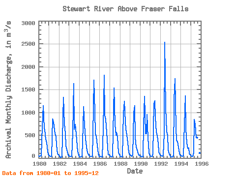
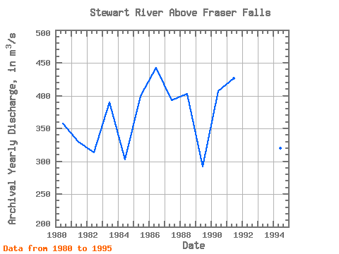
| Year | Jan | Feb | Mar | Apr | May | Jun | Jul | Aug | Sep | Oct | Nov | Dec | Annual | 1980 | 49.20 | 42.40 | 43.10 | 53.50 | 695.00 | 1150.00 | 653.00 | 620.00 | 416.00 | 343.00 | 143.00 | 82.90 | 357.59 | 1981 | 54.30 | 40.80 | 33.70 | 36.60 | 859.00 | 778.00 | 696.00 | 537.00 | 473.00 | 287.00 | 87.90 | 66.70 | 329.17 | 1982 | 49.10 | 24.40 | 20.70 | 25.90 | 433.00 | 1330.00 | 743.00 | 542.00 | 262.00 | 191.00 | 92.20 | 52.60 | 313.82 | 1983 | 44.90 | 41.20 | 34.40 | 37.90 | 549.00 | 1630.00 | 625.00 | 733.00 | 519.00 | 260.00 | 140.00 | 57.70 | 389.34 | 1984 | 24.80 | 26.30 | 29.40 | 40.10 | 699.00 | 1120.00 | 711.00 | 411.00 | 242.00 | 170.00 | 95.40 | 59.80 | 302.40 | 1985 | 48.40 | 43.00 | 33.70 | 34.20 | 524.00 | 1700.00 | 1010.00 | 532.00 | 463.00 | 270.00 | 87.80 | 46.90 | 399.42 | 1986 | 42.40 | 36.50 | 30.00 | 30.10 | 635.00 | 1810.00 | 934.00 | 840.00 | 561.00 | 237.00 | 84.20 | 65.10 | 442.11 | 1987 | 53.60 | 42.10 | 30.80 | 35.40 | 579.00 | 1530.00 | 735.00 | 500.00 | 564.00 | 452.00 | 115.00 | 77.80 | 392.89 | 1988 | 48.60 | 36.90 | 30.60 | 36.80 | 978.00 | 1240.00 | 791.00 | 631.00 | 501.00 | 328.00 | 129.00 | 84.60 | 402.96 | 1989 | 69.90 | 52.40 | 37.90 | 74.30 | 1000.00 | 1150.00 | 445.00 | 240.00 | 181.00 | 130.00 | 71.80 | 55.10 | 292.28 | 1990 | 44.10 | 33.60 | 31.00 | 37.30 | 727.00 | 1350.00 | 530.00 | 535.00 | 956.00 | 445.00 | 120.00 | 71.80 | 406.73 | 1991 | 52.90 | 42.20 | 38.40 | 100.00 | 1190.00 | 1250.00 | 884.00 | 561.00 | 483.00 | 302.00 | 132.00 | 80.60 | 426.34 | 1992 | 63.90 | 49.80 | 43.00 | 64.50 | 542.00 | 2530.00 | 1090.00 | 574.00 | 490.00 | 187.00 | 88.30 | 49.30 | 480.98 | 1993 | 33.60 | 28.10 | 26.30 | 54.10 | 1280.00 | 1740.00 | 677.00 | 382.00 | 372.00 | 227.00 | 97.00 | 73.10 | 415.85 | 1994 | 54.60 | 42.80 | 37.50 | 45.10 | 725.00 | 1360.00 | 643.00 | 327.00 | 215.00 | 223.00 | 93.00 | 73.60 | 319.97 | 1995 | 53.50 | 41.20 | 34.80 | 117.00 | 844.00 | 733.00 | 441.00 | 451.00 | 625.00 | 267.00 | 113.00 | 55.20 | 314.64 |
|---|
 Return to R-Arctic Net Home Page