|
|
|||||||||||||||||
| Point ID: 5797 | Downloads | Plots | Site Data | Code: 09AG001 |
|
|
|||||||||||||||||
| Download | |
|---|---|
| Site Descriptor Information | Site Time Series Data |
| Link to all available data | |
|
|
| View: | Statistics | Time Series |
| Units: | mm |
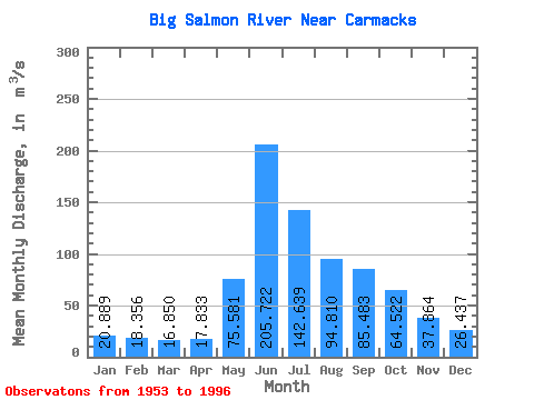
| Statistic | Jan | Feb | Mar | Apr | May | Jun | Jul | Aug | Sep | Oct | Nov | Dec | Annual |
|---|---|---|---|---|---|---|---|---|---|---|---|---|---|
| Mean | 20.89 | 18.36 | 16.85 | 17.83 | 75.58 | 205.72 | 142.64 | 94.81 | 85.48 | 64.52 | 37.86 | 26.44 | 67.49 |
| Standard Deviation | 4.16 | 2.76 | 2.52 | 3.11 | 21.17 | 69.95 | 44.11 | 23.89 | 25.15 | 19.02 | 10.05 | 6.11 | 11.51 |
| Min | 14.30 | 14.60 | 11.70 | 12.30 | 41.50 | 81.00 | 52.80 | 50.20 | 47.50 | 32.60 | 20.70 | 17.30 | 47.76 |
| Max | 37.00 | 26.40 | 22.90 | 25.60 | 132.00 | 376.00 | 244.00 | 160.00 | 143.00 | 123.00 | 62.70 | 50.70 | 91.88 |
| Coefficient of Variation | 0.20 | 0.15 | 0.15 | 0.17 | 0.28 | 0.34 | 0.31 | 0.25 | 0.29 | 0.29 | 0.27 | 0.23 | 0.17 |
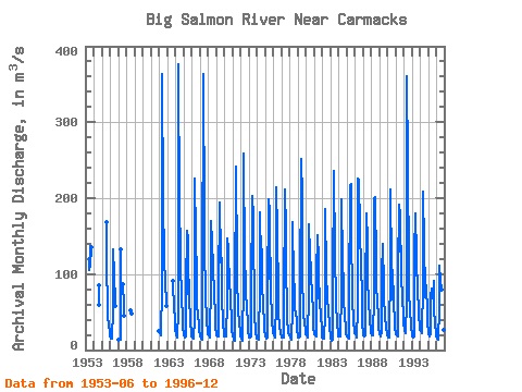
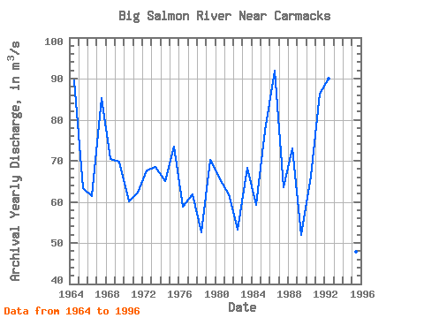
| Year | Jan | Feb | Mar | Apr | May | Jun | Jul | Aug | Sep | Oct | Nov | Dec | Annual | 1953 | 105.00 | 137.00 | 109.00 | 135.00 | 1954 | 85.40 | 58.90 | 1955 | 168.00 | 108.00 | 61.20 | 43.20 | 31.80 | 23.70 | 1956 | 18.00 | 15.50 | 14.70 | 15.20 | 53.70 | 133.00 | 99.10 | 61.90 | 58.30 | 1957 | 14.30 | 14.60 | 14.30 | 13.50 | 132.00 | 86.50 | 58.30 | 45.10 | 1958 | 52.80 | 50.20 | 47.50 | 1962 | 24.90 | 22.10 | 20.40 | 18.70 | 84.50 | 364.00 | 195.00 | 122.00 | 115.00 | 92.30 | 57.80 | 1963 | 91.00 | 86.50 | 56.30 | 39.70 | 1964 | 28.00 | 19.10 | 16.80 | 20.20 | 46.30 | 376.00 | 186.00 | 135.00 | 107.00 | 77.30 | 34.10 | 28.30 | 89.51 | 1965 | 22.40 | 19.00 | 16.90 | 18.60 | 83.30 | 157.00 | 145.00 | 74.30 | 92.80 | 72.60 | 36.00 | 21.80 | 63.31 | 1966 | 17.90 | 16.60 | 16.00 | 15.70 | 41.50 | 226.00 | 148.00 | 96.20 | 56.70 | 49.80 | 28.80 | 24.00 | 61.43 | 1967 | 20.40 | 17.40 | 15.10 | 14.20 | 77.70 | 364.00 | 171.00 | 115.00 | 94.10 | 73.40 | 38.30 | 23.10 | 85.31 | 1968 | 21.20 | 19.50 | 18.00 | 17.00 | 91.20 | 170.00 | 141.00 | 109.00 | 109.00 | 72.90 | 46.90 | 30.30 | 70.50 | 1969 | 19.20 | 19.70 | 18.30 | 17.50 | 79.10 | 194.00 | 124.00 | 116.00 | 121.00 | 71.70 | 32.20 | 25.00 | 69.81 | 1970 | 18.00 | 17.60 | 18.70 | 18.20 | 63.80 | 147.00 | 133.00 | 81.50 | 92.40 | 68.40 | 37.80 | 25.00 | 60.12 | 1971 | 19.90 | 19.10 | 13.50 | 12.30 | 66.50 | 242.00 | 114.00 | 79.10 | 68.20 | 52.60 | 36.90 | 23.40 | 62.29 | 1972 | 18.10 | 15.10 | 11.70 | 12.30 | 90.70 | 259.00 | 116.00 | 94.50 | 76.80 | 54.00 | 38.50 | 23.90 | 67.55 | 1973 | 17.70 | 16.20 | 16.00 | 17.50 | 76.10 | 203.00 | 176.00 | 113.00 | 99.00 | 50.10 | 20.70 | 17.30 | 68.55 | 1974 | 14.90 | 14.80 | 13.30 | 17.20 | 83.10 | 181.00 | 119.00 | 132.00 | 86.70 | 59.50 | 34.50 | 24.40 | 65.03 | 1975 | 19.50 | 18.50 | 15.70 | 16.50 | 72.00 | 198.00 | 181.00 | 94.10 | 121.00 | 80.70 | 39.50 | 23.80 | 73.36 | 1976 | 22.30 | 19.70 | 18.00 | 16.80 | 63.30 | 214.00 | 155.00 | 73.10 | 47.70 | 32.60 | 22.90 | 20.20 | 58.80 | 1977 | 17.90 | 16.70 | 16.10 | 16.40 | 57.70 | 211.00 | 158.00 | 86.30 | 77.40 | 43.10 | 21.70 | 19.00 | 61.77 | 1978 | 20.20 | 15.80 | 14.10 | 16.10 | 52.30 | 169.00 | 90.40 | 83.80 | 54.10 | 47.90 | 40.90 | 26.60 | 52.60 | 1979 | 17.90 | 16.10 | 16.90 | 17.70 | 65.90 | 251.00 | 200.00 | 89.50 | 59.10 | 47.20 | 34.80 | 27.00 | 70.26 | 1980 | 20.60 | 18.90 | 16.50 | 17.40 | 73.70 | 166.00 | 125.00 | 107.00 | 90.70 | 78.90 | 45.20 | 26.10 | 65.50 | 1981 | 24.00 | 21.50 | 20.00 | 17.50 | 101.00 | 151.00 | 121.00 | 68.10 | 81.10 | 63.20 | 44.70 | 28.30 | 61.78 | 1982 | 16.60 | 15.70 | 15.00 | 16.40 | 46.00 | 185.00 | 101.00 | 67.80 | 63.10 | 55.50 | 30.60 | 26.40 | 53.26 | 1983 | 20.50 | 15.10 | 12.80 | 14.30 | 83.40 | 236.00 | 126.00 | 99.50 | 91.90 | 62.70 | 33.10 | 22.80 | 68.17 | 1984 | 18.20 | 18.00 | 18.10 | 20.10 | 72.20 | 199.00 | 117.00 | 85.60 | 66.70 | 44.40 | 30.00 | 21.30 | 59.22 | 1985 | 19.00 | 17.70 | 17.10 | 15.40 | 64.60 | 216.00 | 219.00 | 126.00 | 101.00 | 68.90 | 37.00 | 25.00 | 77.22 | 1986 | 22.20 | 20.20 | 17.50 | 17.10 | 55.20 | 226.00 | 225.00 | 160.00 | 143.00 | 123.00 | 59.70 | 33.70 | 91.88 | 1987 | 22.70 | 19.70 | 17.70 | 19.80 | 73.20 | 180.00 | 142.00 | 80.40 | 75.60 | 67.60 | 37.50 | 26.50 | 63.56 | 1988 | 22.00 | 18.70 | 19.00 | 22.50 | 68.50 | 200.00 | 201.00 | 114.00 | 76.70 | 71.00 | 36.30 | 26.00 | 72.97 | 1989 | 23.60 | 20.70 | 17.60 | 25.60 | 101.00 | 140.00 | 83.20 | 62.70 | 50.70 | 45.90 | 28.50 | 23.10 | 51.88 | 1990 | 19.00 | 15.90 | 15.90 | 23.30 | 106.00 | 211.00 | 108.00 | 66.30 | 105.00 | 63.50 | 35.60 | 27.70 | 66.43 | 1991 | 22.60 | 21.50 | 19.60 | 18.20 | 103.00 | 191.00 | 179.00 | 130.00 | 137.00 | 102.00 | 62.70 | 50.70 | 86.44 | 1992 | 37.00 | 26.40 | 22.90 | 22.60 | 62.40 | 360.00 | 244.00 | 107.00 | 81.20 | 48.30 | 38.50 | 28.50 | 89.90 | 1993 | 21.90 | 17.30 | 16.80 | 18.60 | 126.00 | 180.00 | 122.00 | 97.50 | 98.20 | 84.70 | 45.20 | 31.30 | 71.62 | 1994 | 26.50 | 24.50 | 22.70 | 24.60 | 84.50 | 209.00 | 138.00 | 77.70 | 69.30 | 85.80 | 48.20 | 34.90 | 70.47 | 1995 | 25.60 | 20.90 | 18.60 | 20.10 | 69.10 | 81.00 | 68.80 | 68.10 | 91.60 | 53.70 | 33.30 | 22.30 | 47.76 | 1996 | 17.30 | 15.00 | 14.30 | 16.90 | 50.40 | 111.00 | 91.00 | 79.30 | 93.80 | 47.30 | 26.60 | 24.20 | 48.92 |
|---|
 Return to R-Arctic Net Home Page