|
|
|||||||||||||||||
| Point ID: 579 | Downloads | Plots | Site Data | Code: 06AD013 |
|
|
|||||||||||||||||
| Download | |
|---|---|
| Site Descriptor Information | Site Time Series Data |
| Link to all available data | |
| View: | Time Series | All |
| Units: | m3/s |
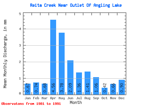
| Statistic | Jan | Feb | Mar | Apr | May | Jun | Jul | Aug | Sep | Oct | Nov | Dec | Annual |
|---|---|---|---|---|---|---|---|---|---|---|---|---|---|
| Mean | 0.67 | 0.75 | 0.68 | 4.56 | 3.77 | 2.09 | 1.36 | 1.41 | 1.06 | 0.42 | 0.66 | 0.90 | 16.35 |
| Standard Deviation | 0.80 | 1.10 | 0.92 | 2.44 | 1.13 | 1.52 | 1.11 | 1.90 | 1.57 | 0.55 | 0.54 | 0.63 | 10.52 |
| Min | 0.00 | 0.00 | 0.00 | 0.97 | 2.18 | 0.13 | 0.02 | 0.00 | 0.02 | 0.00 | 0.11 | 0.07 | 10.41 |
| Max | 1.71 | 2.24 | 3.18 | 9.56 | 5.39 | 5.38 | 3.54 | 6.47 | 4.99 | 1.58 | 1.47 | 1.45 | 35.09 |
| Coefficient of Variation | 1.21 | 1.47 | 1.35 | 0.53 | 0.30 | 0.73 | 0.82 | 1.35 | 1.48 | 1.31 | 0.81 | 0.71 | 0.64 |
 Return to R-Arctic Net Home Page