|
|
| Point ID: 579 | Downloads | Plots | Site Data | Code: 06AD013 |
|
| Download | |
|---|---|
| Site Descriptor Information | Site Time Series Data |
| Link to all available data | |
|
|
|
| View: | Statistics | All |
| Units: | m3/s |
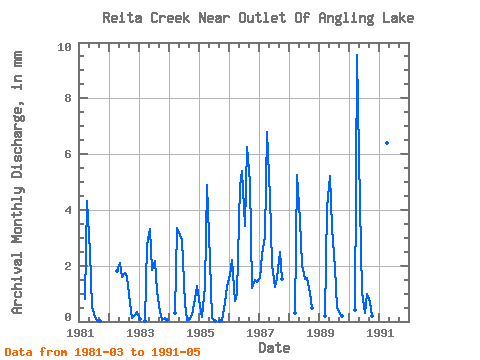
| Year | Jan | Feb | Mar | Apr | May | Jun | Jul | Aug | Sep | Oct | Nov | Dec | Annual | 1981 | 0.83 | 4.33 | 2.58 | 0.52 | 0.17 | 0.03 | 0.02 | 0.00 | 1982 | 0.00 | 0.00 | 0.00 | 1.82 | 2.18 | 1.58 | 1.81 | 1.65 | 0.68 | 0.13 | 0.24 | 0.37 | 10.41 | 1983 | 0.10 | 0.00 | 0.02 | 2.74 | 3.43 | 1.85 | 2.25 | 1.11 | 0.34 | 0.07 | 0.11 | 0.07 | 12.02 | 1984 | 0.00 | 0.00 | 0.30 | 3.37 | 3.21 | 2.93 | 0.65 | 0.05 | 0.08 | 0.23 | 0.81 | 1.31 | 12.94 | 1985 | 0.57 | 0.15 | 1.30 | 4.88 | 2.26 | 0.13 | 0.02 | 0.00 | 0.02 | 0.02 | 0.66 | 1.30 | 11.29 | 1986 | 1.71 | 2.09 | 0.77 | 0.97 | 5.02 | 5.38 | 3.54 | 6.47 | 4.99 | 1.25 | 1.47 | 1.45 | 35.09 | 1987 | 1.61 | 2.24 | 3.18 | 6.78 | 4.61 | 2.04 | 1.28 | 1.61 | 2.50 | 1.58 | 1988 | 0.30 | 5.25 | 3.78 | 2.04 | 1.58 | 1.60 | 1.03 | 0.50 | 1989 | 0.20 | 4.07 | 5.39 | 3.35 | 2.00 | 0.55 | 0.26 | 0.20 | 1990 | 0.43 | 9.56 | 4.33 | 1.06 | 0.30 | 1.03 | 0.71 | 0.22 | 1991 | 0.17 | 6.41 | 4.67 |
|---|
 Return to R-Arctic Net Home Page