|
|
|||||||||||||||||
| Point ID: 570 | Downloads | Plots | Site Data | Code: 06AA901 |
|
|
|||||||||||||||||
| Download | |
|---|---|
| Site Descriptor Information | Site Time Series Data |
| Link to all available data | |
| View: | Time Series | All |
| Units: | m3/s |
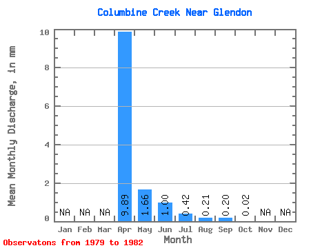
| Statistic | Jan | Feb | Mar | Apr | May | Jun | Jul | Aug | Sep | Oct | Nov | Dec | Annual |
|---|---|---|---|---|---|---|---|---|---|---|---|---|---|
| Mean | 9.40 | 1.57 | 0.95 | 0.39 | 0.20 | 0.19 | 0.02 | ||||||
| Standard Deviation | 4.23 | 1.41 | 1.20 | 0.51 | 0.30 | 0.23 | |||||||
| Min | 6.18 | 0.30 | 0.03 | 0.03 | 0.01 | 0.04 | 0.02 | ||||||
| Max | 14.20 | 3.59 | 2.58 | 1.15 | 0.66 | 0.54 | 0.02 | ||||||
| Coefficient of Variation | 0.45 | 0.90 | 1.26 | 1.29 | 1.52 | 1.25 |
 Return to R-Arctic Net Home Page