|
|
| Point ID: 570 | Downloads | Plots | Site Data | Code: 06AA901 |
|
| Download | |
|---|---|
| Site Descriptor Information | Site Time Series Data |
| Link to all available data | |
|
|
|
| View: | Statistics | All |
| Units: | m3/s |
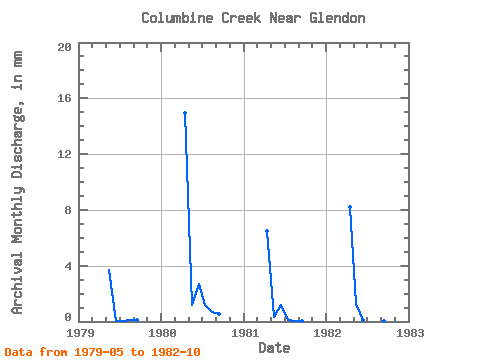
| Year | Jan | Feb | Mar | Apr | May | Jun | Jul | Aug | Sep | Oct | Nov | Dec | Annual | 1979 | 3.59 | 0.03 | 0.03 | 0.08 | 0.11 | 1980 | 14.20 | 1.18 | 2.58 | 1.15 | 0.66 | 0.54 | 1981 | 6.18 | 0.30 | 1.12 | 0.13 | 0.01 | 0.07 | 1982 | 7.83 | 1.22 | 0.07 | 0.27 | 0.06 | 0.04 | 0.02 |
|---|
 Return to R-Arctic Net Home Page