|
|
|||||||||||||||||
| Point ID: 5619 | Downloads | Plots | Site Data | Code: 07MA004 |
|
|
|||||||||||||||||
| Download | |
|---|---|
| Site Descriptor Information | Site Time Series Data |
| Link to all available data | |
| View: | Time Series | All |
| Units: | m3/s |
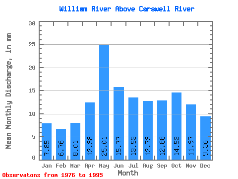
| Statistic | Jan | Feb | Mar | Apr | May | Jun | Jul | Aug | Sep | Oct | Nov | Dec | Annual |
|---|---|---|---|---|---|---|---|---|---|---|---|---|---|
| Mean | 7.85 | 6.82 | 8.01 | 12.38 | 25.01 | 15.77 | 13.53 | 12.72 | 12.88 | 14.52 | 11.97 | 9.36 | 149.02 |
| Standard Deviation | 2.03 | 1.48 | 1.67 | 4.42 | 7.13 | 4.17 | 4.02 | 4.80 | 3.94 | 4.57 | 3.20 | 2.77 | 32.49 |
| Min | 4.15 | 3.77 | 4.80 | 6.69 | 11.76 | 8.62 | 8.04 | 6.37 | 5.49 | 6.02 | 6.08 | 4.43 | 86.61 |
| Max | 12.69 | 10.47 | 11.36 | 22.51 | 36.35 | 20.77 | 21.60 | 22.59 | 19.49 | 25.12 | 17.69 | 14.09 | 189.39 |
| Coefficient of Variation | 0.26 | 0.22 | 0.21 | 0.36 | 0.28 | 0.26 | 0.30 | 0.38 | 0.31 | 0.31 | 0.27 | 0.30 | 0.22 |
 Return to R-Arctic Net Home Page