|
|
|||||||||||||||||
| Point ID: 5618 | Downloads | Plots | Site Data | Code: 07MA003 |
|
|
|||||||||||||||||
| Download | |
|---|---|
| Site Descriptor Information | Site Time Series Data |
| Link to all available data | |
| View: | Time Series | All |
| Units: | m3/s |
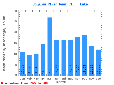
| Statistic | Jan | Feb | Mar | Apr | May | Jun | Jul | Aug | Sep | Oct | Nov | Dec | Annual |
|---|---|---|---|---|---|---|---|---|---|---|---|---|---|
| Mean | 11.07 | 9.46 | 9.94 | 14.63 | 26.62 | 16.36 | 16.50 | 16.42 | 17.70 | 18.72 | 13.69 | 11.96 | 183.17 |
| Standard Deviation | 3.84 | 3.15 | 2.69 | 4.74 | 9.31 | 3.64 | 5.99 | 5.70 | 7.35 | 9.28 | 4.88 | 3.66 | 42.13 |
| Min | 6.43 | 4.75 | 4.75 | 6.30 | 11.12 | 8.99 | 8.57 | 8.57 | 10.18 | 10.68 | 7.59 | 6.23 | 108.41 |
| Max | 22.50 | 16.32 | 15.32 | 27.30 | 48.65 | 25.31 | 31.38 | 29.00 | 41.41 | 53.72 | 30.98 | 22.98 | 290.92 |
| Coefficient of Variation | 0.35 | 0.33 | 0.27 | 0.32 | 0.35 | 0.22 | 0.36 | 0.35 | 0.41 | 0.49 | 0.36 | 0.31 | 0.23 |
 Return to R-Arctic Net Home Page