|
|
|||||||||||||||||
| Point ID: 5606 | Downloads | Plots | Site Data | Code: 06EA011 |
|
|
|||||||||||||||||
| Download | |
|---|---|
| Site Descriptor Information | Site Time Series Data |
| Link to all available data | |
|
|
| View: | Statistics | Time Series |
| Units: | mm |
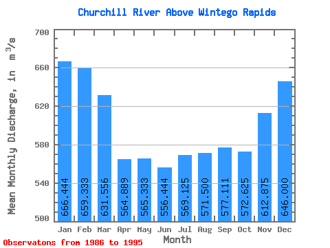
| Statistic | Jan | Feb | Mar | Apr | May | Jun | Jul | Aug | Sep | Oct | Nov | Dec | Annual |
|---|---|---|---|---|---|---|---|---|---|---|---|---|---|
| Mean | 666.44 | 659.33 | 631.56 | 564.89 | 565.33 | 556.44 | 569.12 | 571.50 | 577.11 | 572.62 | 612.88 | 646.00 | 601.94 |
| Standard Deviation | 118.33 | 111.53 | 114.20 | 84.60 | 81.86 | 103.37 | 106.28 | 116.44 | 108.86 | 106.08 | 108.06 | 112.62 | 86.72 |
| Min | 397.00 | 426.00 | 410.00 | 396.00 | 413.00 | 412.00 | 378.00 | 353.00 | 373.00 | 369.00 | 425.00 | 415.00 | 475.83 |
| Max | 774.00 | 786.00 | 761.00 | 690.00 | 661.00 | 760.00 | 725.00 | 710.00 | 704.00 | 690.00 | 767.00 | 770.00 | 728.00 |
| Coefficient of Variation | 0.18 | 0.17 | 0.18 | 0.15 | 0.14 | 0.19 | 0.19 | 0.20 | 0.19 | 0.18 | 0.18 | 0.17 | 0.14 |
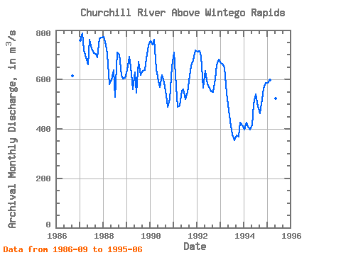
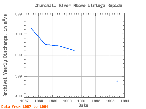
| Year | Jan | Feb | Mar | Apr | May | Jun | Jul | Aug | Sep | Oct | Nov | Dec | Annual | 1986 | 616.00 | 1987 | 758.00 | 786.00 | 718.00 | 690.00 | 661.00 | 760.00 | 725.00 | 707.00 | 704.00 | 690.00 | 767.00 | 770.00 | 728.00 | 1988 | 774.00 | 742.00 | 705.00 | 581.00 | 599.00 | 637.00 | 529.00 | 710.00 | 701.00 | 616.00 | 605.00 | 606.00 | 650.42 | 1989 | 639.00 | 693.00 | 651.00 | 561.00 | 630.00 | 546.00 | 673.00 | 619.00 | 636.00 | 639.00 | 685.00 | 739.00 | 642.58 | 1990 | 756.00 | 740.00 | 761.00 | 641.00 | 596.00 | 568.00 | 619.00 | 589.00 | 536.00 | 490.00 | 520.00 | 653.00 | 622.42 | 1991 | 710.00 | 573.00 | 489.00 | 495.00 | 556.00 | 560.00 | 519.00 | 548.00 | 615.00 | 655.00 | 679.00 | 717.00 | 593.00 | 1992 | 713.00 | 716.00 | 696.00 | 567.00 | 635.00 | 581.00 | 570.00 | 553.00 | 549.00 | 602.00 | 658.00 | 681.00 | 626.75 | 1993 | 666.00 | 661.00 | 646.00 | 546.00 | 474.00 | 412.00 | 378.00 | 353.00 | 373.00 | 369.00 | 425.00 | 415.00 | 476.50 | 1994 | 397.00 | 426.00 | 410.00 | 396.00 | 413.00 | 500.00 | 540.00 | 493.00 | 464.00 | 520.00 | 564.00 | 587.00 | 475.83 | 1995 | 585.00 | 597.00 | 608.00 | 607.00 | 524.00 | 444.00 |
|---|
 Return to R-Arctic Net Home Page