|
|
|||||||||||||||||
| Point ID: 5594 | Downloads | Plots | Site Data | Code: 06CE001 |
|
|
|||||||||||||||||
| Download | |
|---|---|
| Site Descriptor Information | Site Time Series Data |
| Link to all available data | |
| View: | Time Series | All |
| Units: | mm |
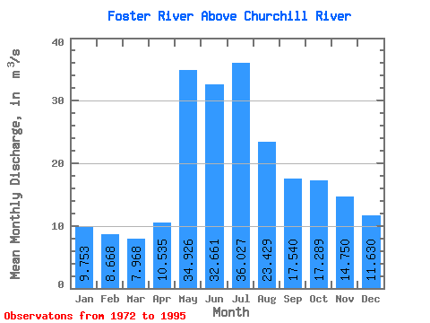
| Statistic | Jan | Feb | Mar | Apr | May | Jun | Jul | Aug | Sep | Oct | Nov | Dec | Annual |
|---|---|---|---|---|---|---|---|---|---|---|---|---|---|
| Mean | 9.75 | 8.67 | 7.97 | 10.54 | 34.93 | 32.66 | 36.03 | 23.43 | 17.54 | 17.29 | 14.75 | 11.63 | 18.85 |
| Standard Deviation | 3.45 | 2.65 | 2.14 | 5.35 | 17.60 | 16.46 | 32.88 | 14.70 | 9.91 | 9.70 | 7.56 | 4.82 | 7.24 |
| Min | 5.07 | 4.58 | 4.77 | 5.30 | 8.79 | 6.54 | 5.40 | 7.32 | 5.13 | 5.31 | 6.30 | 5.83 | 8.46 |
| Max | 16.80 | 13.40 | 11.90 | 26.70 | 70.40 | 66.60 | 166.00 | 70.60 | 40.40 | 40.20 | 34.20 | 22.80 | 33.65 |
| Coefficient of Variation | 0.35 | 0.31 | 0.27 | 0.51 | 0.50 | 0.50 | 0.91 | 0.63 | 0.56 | 0.56 | 0.51 | 0.41 | 0.38 |
 Return to R-Arctic Net Home Page