|
|
|||||||||||||||||
| Point ID: 5594 | Downloads | Plots | Site Data | Code: 06CE001 |
|
|
|||||||||||||||||
| Download | |
|---|---|
| Site Descriptor Information | Site Time Series Data |
| Link to all available data | |
| View: | Time Series | All |
| Units: | m3/s |
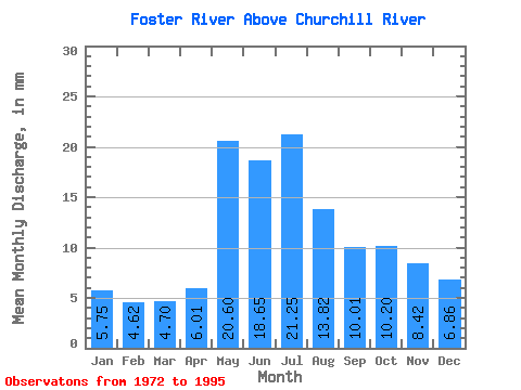
| Statistic | Jan | Feb | Mar | Apr | May | Jun | Jul | Aug | Sep | Oct | Nov | Dec | Annual |
|---|---|---|---|---|---|---|---|---|---|---|---|---|---|
| Mean | 5.75 | 4.66 | 4.70 | 6.01 | 20.60 | 18.65 | 21.25 | 13.82 | 10.01 | 10.20 | 8.42 | 6.86 | 131.05 |
| Standard Deviation | 2.04 | 1.42 | 1.26 | 3.05 | 10.38 | 9.40 | 19.39 | 8.67 | 5.66 | 5.72 | 4.32 | 2.84 | 50.31 |
| Min | 2.99 | 2.46 | 2.81 | 3.03 | 5.18 | 3.73 | 3.19 | 4.32 | 2.93 | 3.13 | 3.60 | 3.44 | 58.80 |
| Max | 9.91 | 7.20 | 7.02 | 15.24 | 41.53 | 38.02 | 97.92 | 41.65 | 23.07 | 23.71 | 19.53 | 13.45 | 233.88 |
| Coefficient of Variation | 0.35 | 0.31 | 0.27 | 0.51 | 0.50 | 0.50 | 0.91 | 0.63 | 0.56 | 0.56 | 0.51 | 0.41 | 0.38 |
 Return to R-Arctic Net Home Page