|
|
| Point ID: 559 | Downloads | Plots | Site Data | Code: 05FE005 |
|
| Download | |
|---|---|
| Site Descriptor Information | Site Time Series Data |
| Link to all available data | |
|
|
|
| View: | Statistics | All |
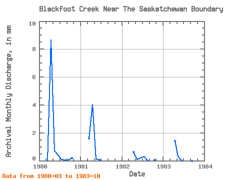
| Units: | m3/s |
| Year | Jan | Feb | Mar | Apr | May | Jun | Jul | Aug | Sep | Oct | Nov | Dec | Annual | 1980 | 0.00 | 2.71 | 0.22 | 0.12 | 0.03 | 0.01 | 0.02 | 0.07 | 1981 | 0.51 | 1.26 | 0.05 | 0.02 | 0.00 | 0.00 | 0.00 | 0.00 | 1982 | 0.00 | 0.19 | 0.03 | 0.07 | 0.10 | 0.00 | 0.00 | 0.02 | 1983 | 0.00 | 0.45 | 0.10 | 0.01 | 0.02 | 0.00 | 0.00 | 0.00 |
|---|
 Return to R-Arctic Net Home Page