|
|
|||||||||||||||||
| Point ID: 5580 | Downloads | Plots | Site Data | Code: 06BB002 |
|
|
|||||||||||||||||
| Download | |
|---|---|
| Site Descriptor Information | Site Time Series Data |
| Link to all available data | |
|
|
| View: | Statistics | Time Series |
| Units: | mm |
| Statistic | Jan | Feb | Mar | Apr | May | Jun | Jul | Aug | Sep | Oct | Nov | Dec | Annual |
|---|---|---|---|---|---|---|---|---|---|---|---|---|---|
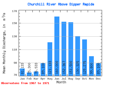
| Mean | 81.13 | 75.30 | 76.53 | 89.10 | 121.13 | 160.00 | 152.37 | 151.50 | 130.32 | 125.28 | 99.80 | 89.10 | 93.77 |
| Standard Deviation | 3.67 | 4.91 | 7.53 | 9.81 | 24.04 | 76.92 | 89.16 | 74.72 | 61.65 | 43.79 | 5.89 | 1.54 | 15.03 |
| Min | 77.00 | 69.90 | 69.70 | 77.80 | 93.40 | 93.00 | 80.10 | 72.00 | 72.30 | 89.10 | 93.40 | 87.80 | 83.14 |
| Max | 84.00 | 79.50 | 84.60 | 95.40 | 136.00 | 244.00 | 252.00 | 243.00 | 216.00 | 189.00 | 105.00 | 90.80 | 104.39 |
| Coefficient of Variation | 0.04 | 0.07 | 0.10 | 0.11 | 0.20 | 0.48 | 0.58 | 0.49 | 0.47 | 0.35 | 0.06 | 0.02 | 0.16 |
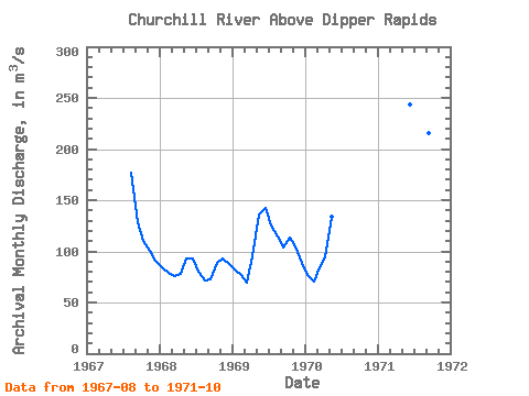
| Year | Jan | Feb | Mar | Apr | May | Jun | Jul | Aug | Sep | Oct | Nov | Dec | Annual | 1967 | 177.00 | 129.00 | 110.00 | 101.00 | 90.80 | 1968 | 84.00 | 79.50 | 75.30 | 77.80 | 93.40 | 93.00 | 80.10 | 72.00 | 72.30 | 89.10 | 93.40 | 87.80 | 83.14 | 1969 | 82.40 | 76.50 | 69.70 | 95.40 | 136.00 | 143.00 | 125.00 | 114.00 | 104.00 | 113.00 | 105.00 | 88.70 | 104.39 | 1970 | 77.00 | 69.90 | 84.60 | 94.10 | 134.00 | 1971 | 244.00 | 252.00 | 243.00 | 216.00 | 189.00 |
|---|
 Return to R-Arctic Net Home Page