|
|
|||||||||||||||||
| Point ID: 5553 | Downloads | Plots | Site Data | Code: 05ND003 |
|
|
|||||||||||||||||
| Download | |
|---|---|
| Site Descriptor Information | Site Time Series Data |
| Link to all available data | |
| View: | Time Series | All |
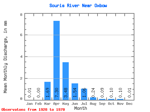
| Units: | m3/s |
| Statistic | Jan | Feb | Mar | Apr | May | Jun | Jul | Aug | Sep | Oct | Nov | Dec | Annual |
|---|---|---|---|---|---|---|---|---|---|---|---|---|---|
| Mean | 0.00 | 0.00 | 0.55 | 2.38 | 1.13 | 0.50 | 0.35 | 0.08 | 0.03 | 0.03 | 0.03 | 0.00 | 4.00 |
| Standard Deviation | 0.00 | 0.00 | 0.76 | 3.01 | 1.75 | 0.72 | 0.67 | 0.11 | 0.04 | 0.05 | 0.07 | 0.01 | 4.98 |
| Min | 0.00 | 0.00 | 0.02 | 0.01 | 0.02 | 0.01 | 0.00 | 0.00 | 0.00 | 0.00 | 0.00 | 0.00 | 0.15 |
| Max | 0.01 | 0.01 | 3.00 | 12.19 | 6.91 | 3.53 | 3.48 | 0.45 | 0.17 | 0.19 | 0.25 | 0.02 | 16.04 |
| Coefficient of Variation | 1.57 | 1.39 | 1.39 | 1.27 | 1.55 | 1.44 | 1.95 | 1.44 | 1.22 | 1.50 | 2.15 | 1.54 | 1.25 |
 Return to R-Arctic Net Home Page