|
|
|||||||||||||||||
| Point ID: 5546 | Downloads | Plots | Site Data | Code: 05NB036 |
|
|
|||||||||||||||||
| Download | |
|---|---|
| Site Descriptor Information | Site Time Series Data |
| Link to all available data | |
|
|
| View: | Statistics | Time Series |
| Units: | mm |
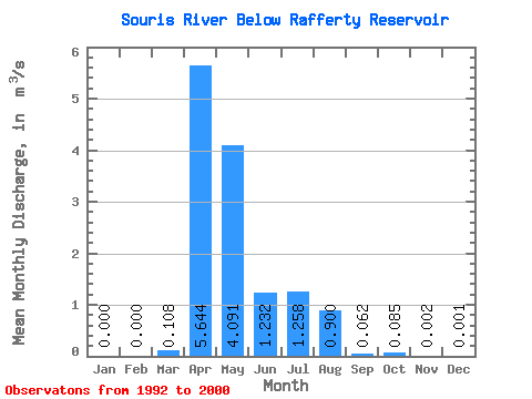
| Statistic | Jan | Feb | Mar | Apr | May | Jun | Jul | Aug | Sep | Oct | Nov | Dec | Annual |
|---|---|---|---|---|---|---|---|---|---|---|---|---|---|
| Mean | 0.00 | 0.00 | 0.11 | 5.64 | 4.09 | 1.23 | 1.26 | 0.90 | 0.06 | 0.09 | 0.00 | 0.00 | 1.11 |
| Standard Deviation | 0.00 | 0.00 | 0.28 | 15.95 | 7.54 | 1.97 | 2.80 | 2.64 | 0.14 | 0.25 | 0.00 | 0.00 | 2.47 |
| Min | 0.00 | 0.00 | 0.00 | 0.00 | 0.00 | 0.00 | 0.00 | 0.00 | 0.00 | 0.00 | 0.00 | 0.00 | 0.00 |
| Max | 0.00 | 0.00 | 0.83 | 48.10 | 21.50 | 5.11 | 8.23 | 7.95 | 0.42 | 0.74 | 0.01 | 0.00 | 7.55 |
| Coefficient of Variation | 2.28 | 2.28 | 2.55 | 2.83 | 1.84 | 1.60 | 2.23 | 2.94 | 2.19 | 2.91 | 1.36 | 1.67 | 2.22 |
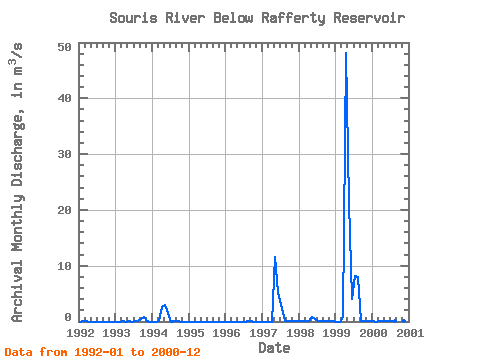
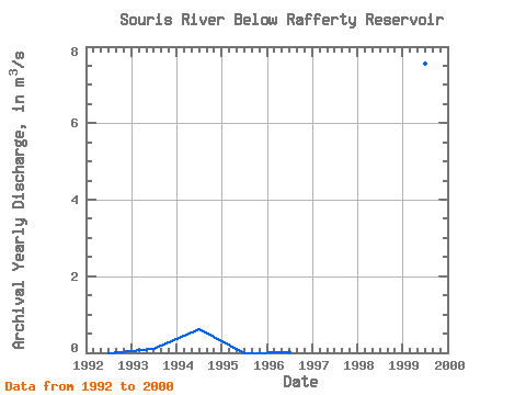
| Year | Jan | Feb | Mar | Apr | May | Jun | Jul | Aug | Sep | Oct | Nov | Dec | Annual | 1992 | 0.00 | 0.00 | 0.00 | 0.00 | 0.00 | 0.00 | 0.00 | 0.00 | 0.00 | 0.00 | 0.00 | 0.00 | 0.00 | 1993 | 0.00 | 0.00 | 0.00 | 0.00 | 0.00 | 0.00 | 0.02 | 0.01 | 0.42 | 0.74 | 0.00 | 0.00 | 0.10 | 1994 | 0.00 | 0.00 | 0.13 | 2.68 | 2.91 | 1.57 | 0.00 | 0.03 | 0.01 | 0.00 | 0.00 | 0.00 | 0.61 | 1995 | 0.00 | 0.00 | 0.00 | 0.00 | 0.00 | 0.00 | 0.00 | 0.00 | 0.00 | 0.00 | 0.00 | 0.00 | 0.00 | 1996 | 0.00 | 0.00 | 0.00 | 0.00 | 0.00 | 0.00 | 0.00 | 0.02 | 0.09 | 0.00 | 0.00 | 0.00 | 0.01 | 1997 | 0.00 | 0.00 | 0.00 | 0.00 | 11.60 | 5.11 | 3.02 | 0.00 | 0.03 | 0.01 | 0.00 | 0.00 | 1.65 | 1998 | 0.00 | 0.00 | 0.00 | 0.01 | 0.80 | 0.40 | 0.05 | 0.09 | 0.00 | 0.00 | 0.00 | 0.00 | 0.11 | 1999 | 0.00 | 0.00 | 0.83 | 48.10 | 21.50 | 4.01 | 8.23 | 7.95 | 0.01 | 0.01 | 0.01 | 0.00 | 7.55 | 2000 | 0.00 | 0.00 | 0.00 | 0.01 | 0.01 | 0.00 | 0.00 | 0.00 | 0.00 | 0.00 | 0.00 | 0.00 | 0.00 |
|---|
 Return to R-Arctic Net Home Page