|
|
|||||||||||||||||
| Point ID: 5542 | Downloads | Plots | Site Data | Code: 05NB031 |
|
|
|||||||||||||||||
| Download | |
|---|---|
| Site Descriptor Information | Site Time Series Data |
| Link to all available data | |
| View: | Time Series | All |
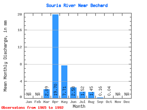
| Units: | m3/s |
| Statistic | Jan | Feb | Mar | Apr | May | Jun | Jul | Aug | Sep | Oct | Nov | Dec | Annual |
|---|---|---|---|---|---|---|---|---|---|---|---|---|---|
| Mean | 0.50 | 4.68 | 1.83 | 0.61 | 0.36 | 0.34 | 0.04 | 0.01 | |||||
| Standard Deviation | 0.90 | 7.52 | 3.44 | 1.56 | 0.88 | 0.80 | 0.11 | 0.03 | |||||
| Min | 0.00 | 0.00 | 0.00 | 0.00 | 0.00 | 0.00 | 0.00 | 0.00 | |||||
| Max | 3.09 | 31.57 | 14.77 | 6.71 | 3.63 | 3.03 | 0.46 | 0.13 | |||||
| Coefficient of Variation | 1.81 | 1.61 | 1.88 | 2.54 | 2.44 | 2.31 | 2.87 | 3.15 |
 Return to R-Arctic Net Home Page