|
|
|||||||||||||||||
| Point ID: 5510 | Downloads | Plots | Site Data | Code: 05MC003 |
|
|
|||||||||||||||||
| Download | |
|---|---|
| Site Descriptor Information | Site Time Series Data |
| Link to all available data | |
| View: | Time Series | All |
| Units: | m3/s |
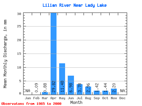
| Statistic | Jan | Feb | Mar | Apr | May | Jun | Jul | Aug | Sep | Oct | Nov | Dec | Annual |
|---|---|---|---|---|---|---|---|---|---|---|---|---|---|
| Mean | 0.06 | 0.59 | 19.92 | 7.67 | 4.66 | 2.53 | 1.98 | 0.95 | 0.96 | 1.47 | |||
| Standard Deviation | 0.81 | 15.12 | 8.83 | 6.07 | 3.12 | 5.88 | 2.33 | 1.11 | 1.55 | ||||
| Min | 0.06 | 0.00 | 2.30 | 0.64 | 0.16 | 0.09 | 0.05 | 0.03 | 0.04 | 0.37 | |||
| Max | 0.06 | 2.89 | 55.35 | 31.34 | 23.43 | 13.21 | 25.49 | 12.45 | 5.71 | 2.57 | |||
| Coefficient of Variation | 1.37 | 0.76 | 1.15 | 1.30 | 1.23 | 2.97 | 2.44 | 1.17 | 1.05 |
 Return to R-Arctic Net Home Page