|
|
|||||||||||||||||
| Point ID: 5497 | Downloads | Plots | Site Data | Code: 05MA025 |
|
|
|||||||||||||||||
| Download | |
|---|---|
| Site Descriptor Information | Site Time Series Data |
| Link to all available data | |
| View: | Time Series | All |
| Units: | m3/s |
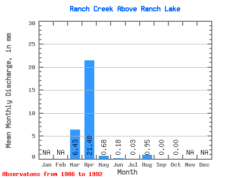
| Statistic | Jan | Feb | Mar | Apr | May | Jun | Jul | Aug | Sep | Oct | Nov | Dec | Annual |
|---|---|---|---|---|---|---|---|---|---|---|---|---|---|
| Mean | 3.29 | 10.99 | 0.35 | 0.10 | 0.02 | 0.49 | 0.00 | 0.00 | |||||
| Standard Deviation | 4.93 | 11.43 | 0.48 | 0.20 | 0.05 | 1.29 | 0.00 | 0.00 | |||||
| Min | 0.00 | 1.63 | 0.00 | 0.00 | 0.00 | 0.00 | 0.00 | 0.00 | |||||
| Max | 12.38 | 30.19 | 1.40 | 0.55 | 0.13 | 3.40 | 0.00 | 0.00 | |||||
| Coefficient of Variation | 1.50 | 1.04 | 1.35 | 2.12 | 2.65 | 2.65 |
 Return to R-Arctic Net Home Page