|
|
|||||||||||||||||
| Point ID: 5479 | Downloads | Plots | Site Data | Code: 05LD003 |
|
|
|||||||||||||||||
| Download | |
|---|---|
| Site Descriptor Information | Site Time Series Data |
| Link to all available data | |
| View: | Time Series | All |
| Units: | m3/s |
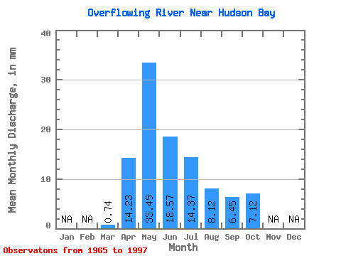
| Statistic | Jan | Feb | Mar | Apr | May | Jun | Jul | Aug | Sep | Oct | Nov | Dec | Annual |
|---|---|---|---|---|---|---|---|---|---|---|---|---|---|
| Mean | 0.74 | 14.19 | 33.39 | 18.51 | 14.33 | 8.10 | 6.43 | 7.10 | |||||
| Standard Deviation | 0.52 | 8.60 | 27.15 | 14.73 | 18.62 | 9.82 | 6.10 | 4.45 | |||||
| Min | 0.00 | 5.21 | 2.30 | 1.78 | 1.68 | 0.29 | 0.39 | 1.04 | |||||
| Max | 1.96 | 35.10 | 107.89 | 59.99 | 84.17 | 43.08 | 20.14 | 16.37 | |||||
| Coefficient of Variation | 0.71 | 0.61 | 0.81 | 0.80 | 1.30 | 1.21 | 0.95 | 0.63 |
 Return to R-Arctic Net Home Page