|
|
|||||||||||||||||
| Point ID: 5418 | Downloads | Plots | Site Data | Code: 05KA003 |
|
|
|||||||||||||||||
| Download | |
|---|---|
| Site Descriptor Information | Site Time Series Data |
| Link to all available data | |
|
|
| View: | Statistics | Time Series |
| Units: | mm |
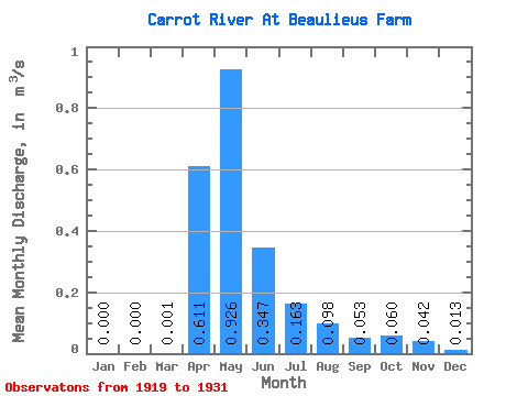
| Statistic | Jan | Feb | Mar | Apr | May | Jun | Jul | Aug | Sep | Oct | Nov | Dec | Annual |
|---|---|---|---|---|---|---|---|---|---|---|---|---|---|
| Mean | 0.00 | 0.00 | 0.00 | 0.61 | 0.93 | 0.35 | 0.16 | 0.10 | 0.05 | 0.06 | 0.04 | 0.01 | 0.44 |
| Standard Deviation | 0.00 | 0.00 | 0.00 | 0.74 | 1.07 | 0.23 | 0.12 | 0.13 | 0.07 | 0.09 | 0.06 | 0.02 | 0.19 |
| Min | 0.00 | 0.00 | 0.00 | 0.04 | 0.06 | 0.03 | 0.03 | 0.00 | 0.00 | 0.00 | 0.00 | 0.00 | 0.32 |
| Max | 0.00 | 0.00 | 0.01 | 2.62 | 3.14 | 0.83 | 0.39 | 0.39 | 0.19 | 0.26 | 0.12 | 0.04 | 0.66 |
| Coefficient of Variation | 2.83 | 1.22 | 1.15 | 0.67 | 0.73 | 1.33 | 1.34 | 1.44 | 1.34 | 1.47 | 0.43 |
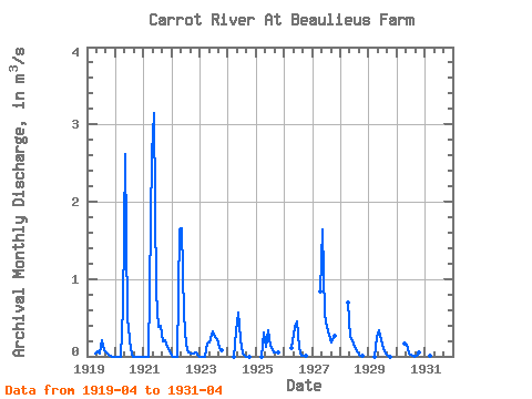
| Year | Jan | Feb | Mar | Apr | May | Jun | Jul | Aug | Sep | Oct | Nov | Dec | Annual | 1919 | 0.04 | 0.06 | 0.03 | 0.21 | 0.07 | 0.05 | 0.03 | 0.00 | 0.00 | 1920 | 0.00 | 0.00 | 0.00 | 0.63 | 2.61 | 0.49 | 0.10 | 0.00 | 0.00 | 0.00 | 0.00 | 0.00 | 0.32 | 1921 | 0.00 | 0.00 | 0.00 | 2.62 | 3.14 | 0.83 | 0.38 | 0.39 | 0.19 | 0.21 | 0.12 | 0.04 | 0.66 | 1922 | 0.00 | 0.00 | 0.00 | 1.64 | 1.66 | 0.54 | 0.15 | 0.05 | 0.03 | 0.03 | 0.05 | 0.01 | 0.35 | 1923 | 0.00 | 0.00 | 0.00 | 0.17 | 0.18 | 0.33 | 0.25 | 0.22 | 0.11 | 0.08 | 1924 | 0.00 | 0.33 | 0.57 | 0.22 | 0.04 | 0.01 | 0.00 | 0.00 | 1925 | 0.00 | 0.30 | 0.13 | 0.33 | 0.14 | 0.05 | 0.05 | 0.05 | 1926 | 0.11 | 0.39 | 0.45 | 0.10 | 0.01 | 0.00 | 0.01 | 1927 | 0.83 | 1.64 | 0.53 | 0.39 | 0.29 | 0.18 | 0.26 | 1928 | 0.70 | 0.25 | 0.17 | 0.09 | 0.05 | 0.00 | 0.00 | 1929 | 0.00 | 0.24 | 0.34 | 0.21 | 0.09 | 0.03 | 0.00 | 0.00 | 1930 | 0.16 | 0.15 | 0.04 | 0.03 | 0.00 | 0.01 | 0.05 | 1931 | 0.01 | 0.17 |
|---|
 Return to R-Arctic Net Home Page