|
|
|||||||||||||||||
| Point ID: 5356 | Downloads | Plots | Site Data | Code: 05JE001 |
|
|
|||||||||||||||||
| Download | |
|---|---|
| Site Descriptor Information | Site Time Series Data |
| Link to all available data | |
| View: | Time Series | All |
| Units: | m3/s |
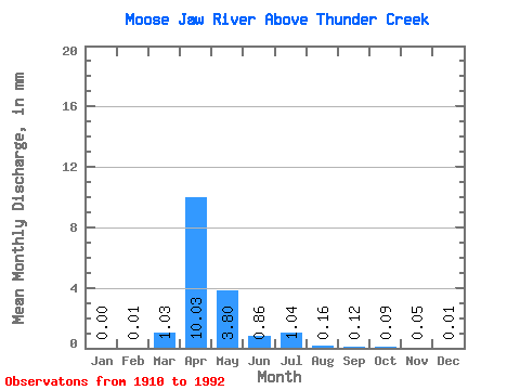
| Statistic | Jan | Feb | Mar | Apr | May | Jun | Jul | Aug | Sep | Oct | Nov | Dec | Annual |
|---|---|---|---|---|---|---|---|---|---|---|---|---|---|
| Mean | 0.00 | 0.01 | 0.56 | 5.40 | 2.05 | 0.46 | 0.56 | 0.09 | 0.06 | 0.05 | 0.03 | 0.01 | 7.50 |
| Standard Deviation | 0.00 | 0.01 | 1.05 | 8.04 | 4.39 | 0.82 | 1.56 | 0.21 | 0.39 | 0.21 | 0.04 | 0.01 | 7.97 |
| Min | 0.00 | 0.00 | 0.00 | 0.00 | 0.00 | 0.00 | 0.00 | 0.00 | 0.00 | 0.00 | 0.00 | 0.00 | 0.03 |
| Max | 0.01 | 0.05 | 6.43 | 33.13 | 19.74 | 4.70 | 9.79 | 1.31 | 3.23 | 1.70 | 0.15 | 0.03 | 24.26 |
| Coefficient of Variation | 1.94 | 1.92 | 1.89 | 1.49 | 2.14 | 1.77 | 2.77 | 2.51 | 6.36 | 4.59 | 1.57 | 1.80 | 1.06 |
 Return to R-Arctic Net Home Page