|
|
|||||||||||||||||
| Point ID: 5339 | Downloads | Plots | Site Data | Code: 05JA001 |
|
|
|||||||||||||||||
| Download | |
|---|---|
| Site Descriptor Information | Site Time Series Data |
| Link to all available data | |
|
|
| View: | Statistics | Time Series |
| Units: | mm |
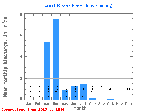
| Statistic | Jan | Feb | Mar | Apr | May | Jun | Jul | Aug | Sep | Oct | Nov | Dec | Annual |
|---|---|---|---|---|---|---|---|---|---|---|---|---|---|
| Mean | 0.00 | 0.00 | 5.36 | 7.50 | 0.90 | 1.26 | 1.45 | 0.15 | 0.01 | 0.06 | 0.01 | 0.00 | 0.92 |
| Standard Deviation | 0.00 | 0.00 | 8.75 | 5.43 | 0.74 | 2.62 | 3.50 | 0.33 | 0.03 | 0.09 | 0.02 | 0.00 | 0.56 |
| Min | 0.00 | 0.00 | 0.02 | 1.70 | 0.34 | 0.02 | 0.00 | 0.00 | 0.00 | 0.00 | 0.00 | 0.00 | 0.51 |
| Max | 0.00 | 0.00 | 29.30 | 18.40 | 2.68 | 8.15 | 10.10 | 0.97 | 0.09 | 0.21 | 0.06 | 0.00 | 1.85 |
| Coefficient of Variation | 1.63 | 0.72 | 0.83 | 2.07 | 2.41 | 2.17 | 2.05 | 1.43 | 1.68 | 2.45 | 0.61 |
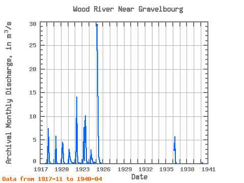
| Year | Jan | Feb | Mar | Apr | May | Jun | Jul | Aug | Sep | Oct | Nov | Dec | Annual | 1917 | 0.02 | 0.00 | 1918 | 0.00 | 0.00 | 7.32 | 3.79 | 0.57 | 0.14 | 0.00 | 0.00 | 0.00 | 0.00 | 0.00 | 0.00 | 0.98 | 1919 | 0.00 | 0.00 | 0.02 | 5.73 | 0.34 | 0.02 | 0.02 | 0.00 | 0.00 | 0.00 | 0.00 | 0.00 | 0.51 | 1920 | 0.00 | 0.00 | 4.45 | 3.85 | 0.48 | 0.10 | 0.03 | 0.00 | 0.00 | 0.00 | 0.00 | 0.00 | 0.74 | 1921 | 0.00 | 0.00 | 2.94 | 1.70 | 0.55 | 0.35 | 0.22 | 0.08 | 0.03 | 0.21 | 0.01 | 0.00 | 0.51 | 1922 | 0.00 | 0.00 | 4.98 | 14.00 | 2.68 | 0.30 | 0.21 | 0.04 | 0.00 | 0.00 | 0.00 | 0.00 | 1.85 | 1923 | 0.00 | 0.00 | 1.65 | 7.63 | 0.59 | 8.15 | 10.10 | 0.97 | 0.09 | 0.06 | 0.06 | 1924 | 0.06 | 2.86 | 0.93 | 1.11 | 0.69 | 0.11 | 0.00 | 0.15 | 1925 | 29.30 | 18.40 | 1.41 | 1.15 | 0.34 | 0.03 | 0.00 | 1936 | 2.82 | 5.62 | 0.53 | 0.04 | 1940 | 0.05 | 11.40 |
|---|
 Return to R-Arctic Net Home Page