|
|
|||||||||||||||||
| Point ID: 5316 | Downloads | Plots | Site Data | Code: 05HF015 |
|
|
|||||||||||||||||
| Download | |
|---|---|
| Site Descriptor Information | Site Time Series Data |
| Link to all available data | |
| View: | Time Series | All |
| Units: | m3/s |
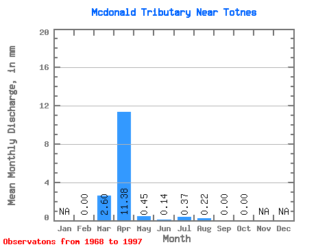
| Statistic | Jan | Feb | Mar | Apr | May | Jun | Jul | Aug | Sep | Oct | Nov | Dec | Annual |
|---|---|---|---|---|---|---|---|---|---|---|---|---|---|
| Mean | 0.02 | 2.06 | 8.88 | 0.35 | 0.09 | 0.27 | 0.20 | 0.00 | 0.01 | ||||
| Standard Deviation | 0.03 | 4.67 | 13.79 | 0.58 | 0.26 | 0.96 | 0.85 | 0.01 | 0.02 | ||||
| Min | 0.00 | 0.00 | 0.06 | 0.00 | 0.00 | 0.00 | 0.00 | 0.00 | 0.00 | ||||
| Max | 0.05 | 20.74 | 44.71 | 2.38 | 1.41 | 5.05 | 4.53 | 0.06 | 0.12 | ||||
| Coefficient of Variation | 1.55 | 2.27 | 1.55 | 1.63 | 2.81 | 3.63 | 4.33 | 5.48 | 4.03 |
 Return to R-Arctic Net Home Page