|
|
|||||||||||||||||
| Point ID: 5302 | Downloads | Plots | Site Data | Code: 05HD037 |
|
|
|||||||||||||||||
| Download | |
|---|---|
| Site Descriptor Information | Site Time Series Data |
| Link to all available data | |
|
|
| View: | Statistics | Time Series |
| Units: | mm |
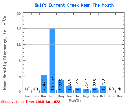
| Statistic | Jan | Feb | Mar | Apr | May | Jun | Jul | Aug | Sep | Oct | Nov | Dec | Annual |
|---|---|---|---|---|---|---|---|---|---|---|---|---|---|
| Mean | 4.45 | 16.06 | 3.23 | 1.60 | 1.19 | 0.95 | 1.22 | 1.76 | |||||
| Standard Deviation | 5.30 | 12.56 | 2.73 | 0.97 | 0.71 | 0.47 | 0.62 | 0.60 | |||||
| Min | 0.50 | 1.79 | 1.24 | 0.71 | 0.46 | 0.38 | 0.45 | 0.94 | |||||
| Max | 15.90 | 31.10 | 9.58 | 3.46 | 2.26 | 1.55 | 2.04 | 2.63 | |||||
| Coefficient of Variation | 1.19 | 0.78 | 0.84 | 0.60 | 0.60 | 0.50 | 0.51 | 0.34 |
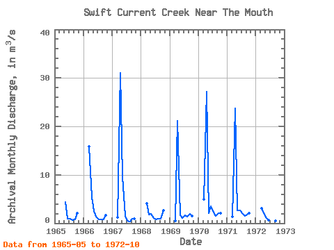
| Year | Jan | Feb | Mar | Apr | May | Jun | Jul | Aug | Sep | Oct | Nov | Dec | Annual | 1965 | 4.34 | 0.88 | 0.95 | 0.64 | 0.86 | 2.09 | 1966 | 15.90 | 5.40 | 2.44 | 1.36 | 0.73 | 0.79 | 0.85 | 1.71 | 1967 | 1.28 | 31.10 | 9.58 | 1.51 | 0.54 | 0.40 | 0.90 | 0.94 | 1968 | 4.08 | 1.79 | 1.95 | 1.13 | 0.83 | 0.95 | 0.90 | 2.63 | 1969 | 0.50 | 21.10 | 1.59 | 1.08 | 1.66 | 1.40 | 2.00 | 1.46 | 1970 | 4.90 | 27.20 | 2.12 | 3.46 | 2.26 | 1.45 | 2.04 | 2.13 | 1971 | 1.40 | 23.70 | 2.62 | 2.70 | 2.10 | 1.55 | 1.80 | 2.15 | 1972 | 3.07 | 2.11 | 1.24 | 0.71 | 0.46 | 0.38 | 0.45 | 0.96 |
|---|
 Return to R-Arctic Net Home Page