|
|
|||||||||||||||||
| Point ID: 5297 | Downloads | Plots | Site Data | Code: 05HD029 |
|
|
|||||||||||||||||
| Download | |
|---|---|
| Site Descriptor Information | Site Time Series Data |
| Link to all available data | |
| View: | Time Series | All |
| Units: | m3/s |
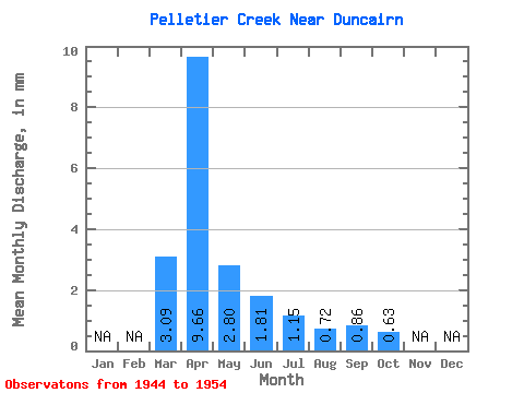
| Statistic | Jan | Feb | Mar | Apr | May | Jun | Jul | Aug | Sep | Oct | Nov | Dec | Annual |
|---|---|---|---|---|---|---|---|---|---|---|---|---|---|
| Mean | 2.85 | 8.89 | 2.57 | 1.66 | 1.05 | 0.67 | 0.79 | 0.57 | |||||
| Standard Deviation | 2.70 | 11.42 | 2.34 | 1.42 | 1.06 | 0.89 | 0.87 | 0.43 | |||||
| Min | 0.00 | 1.30 | 0.49 | 0.37 | 0.07 | 0.00 | 0.04 | 0.23 | |||||
| Max | 7.03 | 41.47 | 7.06 | 4.38 | 3.33 | 2.81 | 2.43 | 1.69 | |||||
| Coefficient of Variation | 0.95 | 1.28 | 0.91 | 0.85 | 1.01 | 1.32 | 1.11 | 0.75 |
 Return to R-Arctic Net Home Page