|
|
|||||||||||||||||
| Point ID: 5215 | Downloads | Plots | Site Data | Code: 05GC007 |
|
|
|||||||||||||||||
| Download | |
|---|---|
| Site Descriptor Information | Site Time Series Data |
| Link to all available data | |
| View: | Time Series | All |
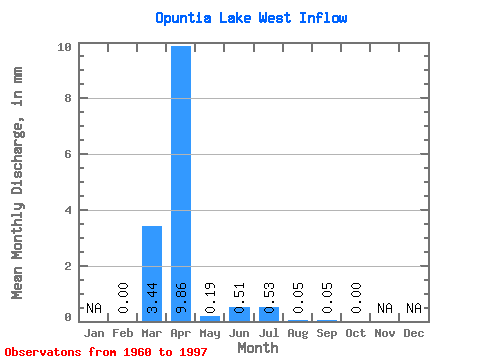
| Units: | m3/s |
| Statistic | Jan | Feb | Mar | Apr | May | Jun | Jul | Aug | Sep | Oct | Nov | Dec | Annual |
|---|---|---|---|---|---|---|---|---|---|---|---|---|---|
| Mean | 0.00 | 2.04 | 5.84 | 0.12 | 0.30 | 0.32 | 0.01 | 0.02 | 0.01 | ||||
| Standard Deviation | 0.00 | 3.80 | 8.93 | 0.41 | 1.29 | 1.20 | 0.06 | 0.12 | 0.05 | ||||
| Min | 0.00 | 0.00 | 0.00 | 0.00 | 0.00 | 0.00 | 0.00 | 0.00 | 0.00 | ||||
| Max | 0.00 | 20.94 | 35.38 | 2.18 | 7.82 | 5.47 | 0.34 | 0.71 | 0.31 | ||||
| Coefficient of Variation | 1.87 | 1.53 | 3.42 | 4.31 | 3.76 | 3.94 | 6.08 | 4.92 |
 Return to R-Arctic Net Home Page